Yuyapichis elevation
Yuyapichis (Huanuco, Puerto Inca), Peru elevation is 216 meters and Yuyapichis elevation in feet is 709 ft above sea level [src 1]. Yuyapichis is a seat of a third-order administrative division (feature code) with elevation that is 2105 meters (6906 ft) smaller than average city elevation in Peru.
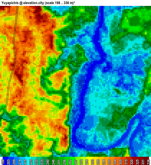
Below is the Elevation map of Yuyapichis, which displays elevation range with different colors. Scale of the first map is from 198 to 336 m (650 to 1102 ft) with average elevation of 250.4 meters (=822 ft) [note 1]
These maps also provides idea of topography and contour of this city, they are displayed at different zoom levels. More info about maps, scale and edge coordinates you can find below images.
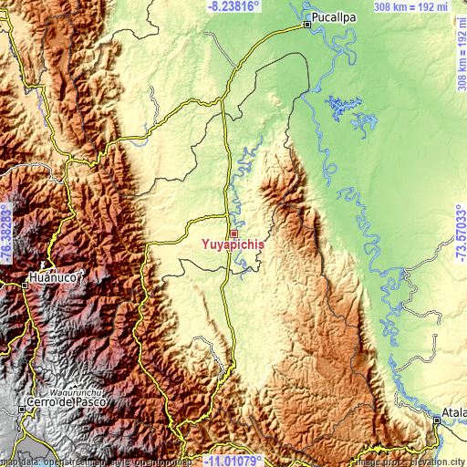
| \ | Map #1 | Topo.Map |
| Scale [m] | 198..336 m | × |
| Scale [ft] | 650..1102 ft | × |
| Average | 250.4 m = 822 ft | × |
| Width | 9.63 km = 6 mi | 308.3 km = 191.6 mi |
| Height | 9.63 km = 6 mi | 308.3 km = 191.6 mi |
| ↑Max Latitude | -9.583991° | -8.23816° |
| Latitude at center | -9.62732° | -9.62732° |
| ↓Min Latitude | -9.670644° | -11.01079° |
| ← Min Longitude | -75.020525° | -76.38283° |
| Longitude center | -74.97658° | -74.97658° |
| →Max Longitude | -74.932635° | -73.57033° |
Nearby cities:
Cities around Yuyapichis sort by population:
• Tingo María elevation 647 m
117.7 km,  288°
288°
• Oxapampa 1814 m
115.4 km,  203°
203°
• Bolognesi 173 m
117 km,  114°
114°
• Las Palmas 1092 m
116 km,  283°
283°
• Panao 2504 m
115.4 km,  254°
254°
• Chaglla 3011 m
104.3 km,  256°
256°
• Huancabamba 1965 m
100.9 km,  217°
217°
• Honoria 169 m
99.8 km,  17°
17°
• Tournavista 190 m
83 km, 20°
• Pozuzo 1135 m
78.1 km,  231°
231°
• Iparia 239 m
60.7 km,  53°
53°
• Puerto Inca 205 m
27.9 km,  2°
2°
Multilingual:
 En español:
Yuyapichis elevación 216 m.
 En France:
Yuyapichis élévation 216 m.
 Auf Deutsch:
Yuyapichis höhe über dem Meeresspiegel ist 216 m.

Sources and notes:
- [note 1] Map square and city borders are not equal. Map elevation data is calculated only from area inside that square.
- [src 1] Elevation data from geonames database provided with same terms of usage.
- [src 2] The elevation map of Yuyapichis is generated using elevation data from NASA's 3 arcsec (90m) resolution SRTM data.
- [src 3] Base (background) map © OpenStreetMap contributors tiles are generated by Geofabrik and OpenTopoMap.
Copyright & License:
This Yuyapichis Elevation Map is licensed under CC BY-SA. You may reuse any part from this page, if you give a proper credit by linking to this URL:
 More info on terms of use page.