Honoria elevation
Honoria (Huanuco, Puerto Inca), Peru elevation is 169 meters and Honoria elevation in feet is 554 ft above sea level [src 1]. Honoria is a seat of a third-order administrative division (feature code) with elevation that is 2152 meters (7060 ft) smaller than average city elevation in Peru.
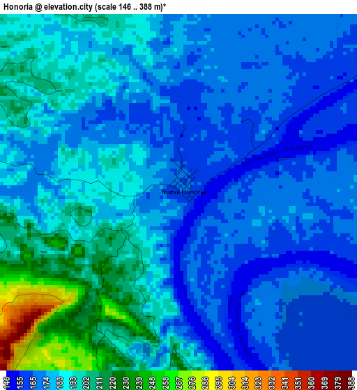
Below is the Elevation map of Honoria, which displays elevation range with different colors. Scale of the first map is from 146 to 388 m (479 to 1273 ft) with average elevation of 182.9 meters (=600 ft) [note 1]
These maps also provides idea of topography and contour of this city, they are displayed at different zoom levels. More info about maps, scale and edge coordinates you can find below images.
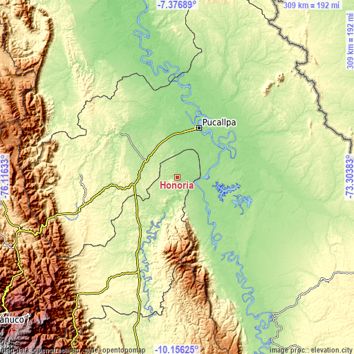
| \ | Map #1 | Topo.Map |
| Scale [m] | 146..388 m | × |
| Scale [ft] | 479..1273 ft | × |
| Average | 182.9 m = 600 ft | × |
| Width | 9.66 km = 6 mi | 309 km = 192 mi |
| Height | 9.66 km = 6 mi | 309.1 km = 192.1 mi |
| ↑Max Latitude | -8.725736° | -7.37689° |
| Latitude at center | -8.76917° | -8.76917° |
| ↓Min Latitude | -8.812599° | -10.15625° |
| ← Min Longitude | -74.754025° | -76.11633° |
| Longitude center | -74.71008° | -74.71008° |
| →Max Longitude | -74.666135° | -73.30383° |
Nearby cities:
Cities around Honoria sort by population:
• Pucallpa elevation 155 m
46.6 km,  21°
21°
• Tingo María 647 m
152.8 km,  247°
247°
• Campoverde 198 m
34.4 km,  341°
341°
• Las Palmas 1092 m
157.8 km,  244°
244°
• Aucayacu 569 m
155.2 km,  263°
263°
• Yuyapichis 216 m
99.8 km,  197°
197°
• Puerto Inca 205 m
73.2 km, 202°
• Iparia 239 m
62.1 km,  161°
161°
• Nueva Requena 151 m
53.6 km, 341°
• Masisea 156 m
48.1 km,  67°
67°
• Puerto Callao 153 m
48.1 km, 18°
• Tournavista 190 m
17.8 km,  179°
179°
Multilingual:
 En español:
Honoria elevación 169 m.
 En France:
Honoria élévation 169 m.


Sources and notes:
- [note 1] Map square and city borders are not equal. Map elevation data is calculated only from area inside that square.
- [src 1] Elevation data from geonames database provided with same terms of usage.
- [src 2] The elevation map of Honoria is generated using elevation data from NASA's 3 arcsec (90m) resolution SRTM data.
- [src 3] Base (background) map © OpenStreetMap contributors tiles are generated by Geofabrik and OpenTopoMap.
Copyright & License:
This Honoria Elevation Map is licensed under CC BY-SA. You may reuse any part from this page, if you give a proper credit by linking to this URL:
 More info on terms of use page.