Campoverde elevation
Campoverde (Ucayali, Provincia de Coronel Portillo), Peru elevation is 198 meters and Campoverde elevation in feet is 650 ft above sea level [src 1]. Campoverde is a populated place (feature code) with elevation that is 2123 meters (6965 ft) smaller than average city elevation in Peru.
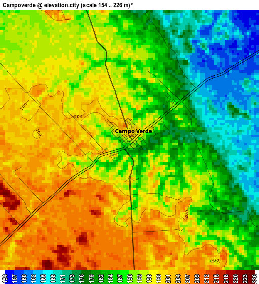
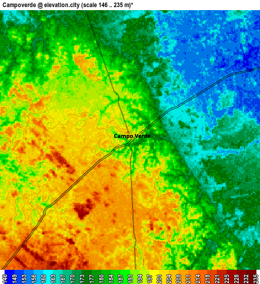
Below is the Elevation map of Campoverde, which displays elevation range with different colors. Scale of the first map is from 154 to 226 m (505 to 741 ft) with average elevation of 191 meters (=627 ft) [note 1]
These maps also provides idea of topography and contour of this city, they are displayed at different zoom levels. More info about maps, scale and edge coordinates you can find below images.
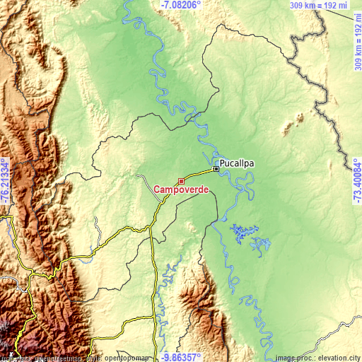
| \ | Map #1 | Map #2 | Topo.Map |
| Scale [m] | 154..226 m | 146..235 m | × |
| Scale [ft] | 505..741 ft | 479..771 ft | × |
| Average | 191 m = 627 ft | 185.8 m = 610 ft | × |
| Width | 9.67 km = 6 mi | 19.33 km = 12 mi | 309.3 km = 192.2 mi |
| Height | 9.67 km = 6 mi | 19.33 km = 12 mi | 309.3 km = 192.2 mi |
| ↑Max Latitude | -8.431862° | -8.388389° | -7.08206° |
| Latitude at center | -8.47533° | -8.47533° | -8.47533° |
| ↓Min Latitude | -8.518793° | -8.562251° | -9.86357° |
| ← Min Longitude | -74.851035° | -74.894981° | -76.21334° |
| Longitude center | -74.80709° | -74.80709° | -74.80709° |
| →Max Longitude | -74.763145° | -74.719199° | -73.40084° |
Nearby cities:
Cities around Campoverde sort by population:
• Pucallpa elevation 155 m
29.8 km,  68°
68°
• Contamana 147 m
129.1 km,  349°
349°
• Aucayacu 569 m
152.2 km,  250°
250°
• Pampa Hermosa 132 m
151.8 km,  339°
339°
• Yuyapichis 216 m
129.4 km,  188°
188°
• Puerto Inca 205 m
101.8 km, 189°
• Iparia 239 m
96.5 km,  161°
161°
• Masisea 156 m
57.1 km,  104°
104°
• Tournavista 190 m
51.7 km,  167°
167°
• Honoria 169 m
34.4 km, 161°
• Puerto Callao 153 m
28.8 km,  63°
63°
• Nueva Requena 151 m
19.2 km, 341°
Multilingual:
 En español:
Campoverde elevación 198 m.
 En France:
Campoverde élévation 198 m.
 Auf Deutsch:
Campoverde höhe über dem Meeresspiegel ist 198 m.

Sources and notes:
- [note 1] Map square and city borders are not equal. Map elevation data is calculated only from area inside that square.
- [src 1] Elevation data from geonames database provided with same terms of usage.
- [src 2] The elevation map of Campoverde is generated using elevation data from NASA's 3 arcsec (90m) resolution SRTM data.
- [src 3] Base (background) map © OpenStreetMap contributors tiles are generated by Geofabrik and OpenTopoMap.
Copyright & License:
This Campoverde Elevation Map is licensed under CC BY-SA. You may reuse any part from this page, if you give a proper credit by linking to this URL:
 More info on terms of use page.