Las Palmas elevation
Las Palmas (Huanuco, Provincia de Leoncio Prado), Peru elevation is 1092 meters and Las Palmas elevation in feet is 3583 ft above sea level [src 1]. Las Palmas is a seat of a third-order administrative division (feature code) with elevation that is 1229 meters (4032 ft) smaller than average city elevation in Peru.
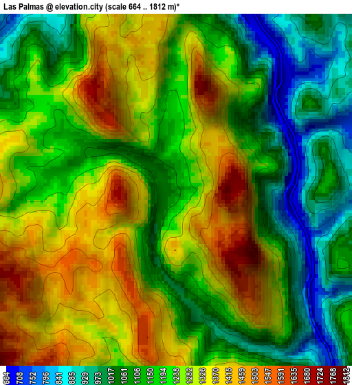
Below is the Elevation map of Las Palmas, which displays elevation range with different colors. Scale of the first map is from 664 to 1812 m (2178 to 5945 ft) with average elevation of 1214.1 meters (=3983 ft) [note 1]
These maps also provides idea of topography and contour of this city, they are displayed at different zoom levels. More info about maps, scale and edge coordinates you can find below images.
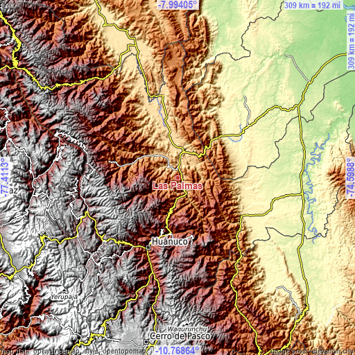
| \ | Map #1 | Topo.Map |
| Scale [m] | 664..1812 m | × |
| Scale [ft] | 2178..5945 ft | × |
| Average | 1214.1 m = 3983 ft | × |
| Width | 9.64 km = 6 mi | 308.5 km = 191.7 mi |
| Height | 9.64 km = 6 mi | 308.5 km = 191.7 mi |
| ↑Max Latitude | -9.34076° | -7.99405° |
| Latitude at center | -9.38412° | -9.38412° |
| ↓Min Latitude | -9.427474° | -10.76864° |
| ← Min Longitude | -76.048995° | -77.4113° |
| Longitude center | -76.00505° | -76.00505° |
| →Max Longitude | -75.961105° | -74.5988° |
Nearby cities:
Cities around Las Palmas sort by population:
• Huánuco elevation 1900 m
66.1 km,  203°
203°
• Tingo María 647 m
9.9 km,  5°
5°
• Tantamayo 3623 m
78.8 km,  269°
269°
• Conchamarca 2171 m
76.2 km, 197°
• Huancapallac 2860 m
72.3 km,  218°
218°
• Cayhuayna 1932 m
69.2 km, 202°
• Paucarbamba 2690 m
66.7 km, 200°
• Panao 2504 m
57.1 km,  178°
178°
• Chaglla 3011 m
52.3 km,  167°
167°
• Aucayacu 569 m
51.7 km,  346°
346°
• Churubamba 1918 m
51.1 km, 195°
• Acomayo 2109 m
46.9 km,  188°
188°
Multilingual:
 En español:
Las Palmas elevación 1092 m.
 En France:
Las Palmas élévation 1092 m.
 Auf Deutsch:
Las Palmas höhe über dem Meeresspiegel ist 1092 m.

Sources and notes:
- [note 1] Map square and city borders are not equal. Map elevation data is calculated only from area inside that square.
- [src 1] Elevation data from geonames database provided with same terms of usage.
- [src 2] The elevation map of Las Palmas is generated using elevation data from NASA's 3 arcsec (90m) resolution SRTM data.
- [src 3] Base (background) map © OpenStreetMap contributors tiles are generated by Geofabrik and OpenTopoMap.
Copyright & License:
This Las Palmas Elevation Map is licensed under CC BY-SA. You may reuse any part from this page, if you give a proper credit by linking to this URL:
 More info on terms of use page.