Panao elevation
Panao (Huanuco, Provincia de Pachitea), Peru elevation is 2504 meters and Panao elevation in feet is 8215 ft above sea level [src 1]. Panao is a seat of a third-order administrative division (feature code) with elevation that is 183 meters (600 ft) bigger than average city elevation in Peru.
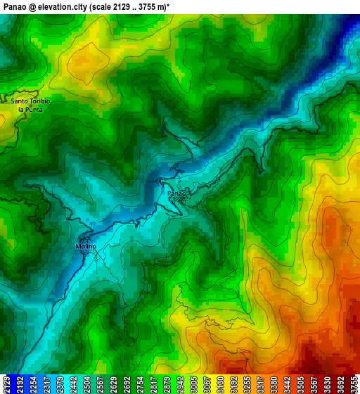
Below is the Elevation map of Panao, which displays elevation range with different colors. Scale of the first map is from 2129 to 3755 m (6985 to 12320 ft) with average elevation of 2797.3 meters (=9177 ft) [note 1]
These maps also provides idea of topography and contour of this city, they are displayed at different zoom levels. More info about maps, scale and edge coordinates you can find below images.
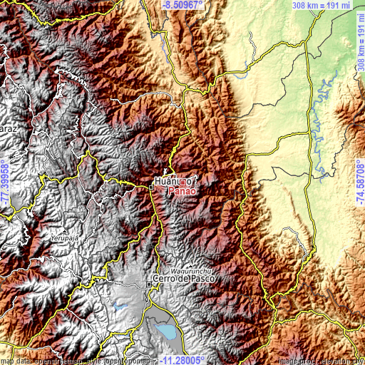
| \ | Map #1 | Topo.Map |
| Scale [m] | 2129..3755 m | × |
| Scale [ft] | 6985..12320 ft | × |
| Average | 2797.3 m = 9177 ft | × |
| Width | 9.63 km = 6 mi | 308 km = 191.4 mi |
| Height | 9.63 km = 6 mi | 308.1 km = 191.4 mi |
| ↑Max Latitude | -9.854486° | -8.50967° |
| Latitude at center | -9.89778° | -9.89778° |
| ↓Min Latitude | -9.941068° | -11.28005° |
| ← Min Longitude | -76.037275° | -77.39958° |
| Longitude center | -75.99333° | -75.99333° |
| →Max Longitude | -75.949385° | -74.58708° |
Nearby cities:
Cities around Panao sort by population:
• Huánuco elevation 1900 m
27.5 km,  262°
262°
• Ambo 2098 m
34.7 km,  221°
221°
• San Rafael 2720 m
53.2 km,  203°
203°
• Huancapallac 2860 m
46.1 km,  270°
270°
• Huacar 2117 m
39.5 km, 222°
• Tomay Kichwa 2034 m
31.2 km,  230°
230°
• Conchamarca 2171 m
28.9 km,  237°
237°
• Cayhuayna 1932 m
28.8 km, 256°
• Paucarbamba 2690 m
25.7 km, 258°
• Churubamba 1918 m
17.3 km,  297°
297°
• Acomayo 2109 m
13.8 km,  321°
321°
• Chaglla 3011 m
11.6 km,  58°
58°
Multilingual:
 En español:
Panao elevación 2504 m.
 En France:
Panao élévation 2504 m.


Sources and notes:
- [note 1] Map square and city borders are not equal. Map elevation data is calculated only from area inside that square.
- [src 1] Elevation data from geonames database provided with same terms of usage.
- [src 2] The elevation map of Panao is generated using elevation data from NASA's 3 arcsec (90m) resolution SRTM data.
- [src 3] Base (background) map © OpenStreetMap contributors tiles are generated by Geofabrik and OpenTopoMap.
Copyright & License:
This Panao Elevation Map is licensed under CC BY-SA. You may reuse any part from this page, if you give a proper credit by linking to this URL:
 More info on terms of use page.