Huancabamba elevation
Huancabamba (Pasco, Provincia de Oxapampa), Peru elevation is 1965 meters and Huancabamba elevation in feet is 6447 ft above sea level [src 1]. Huancabamba is a seat of a third-order administrative division (feature code) with elevation that is 356 meters (1168 ft) smaller than average city elevation in Peru.
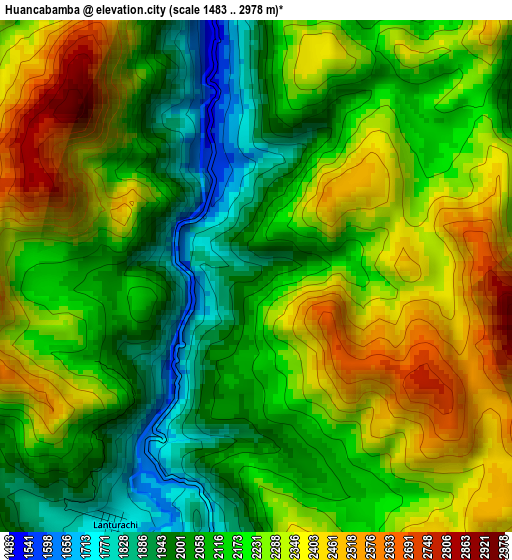
Below is the Elevation map of Huancabamba, which displays elevation range with different colors. Scale of the first map is from 1483 to 2978 m (4865 to 9770 ft) with average elevation of 2193.4 meters (=7196 ft) [note 1]
These maps also provides idea of topography and contour of this city, they are displayed at different zoom levels. More info about maps, scale and edge coordinates you can find below images.
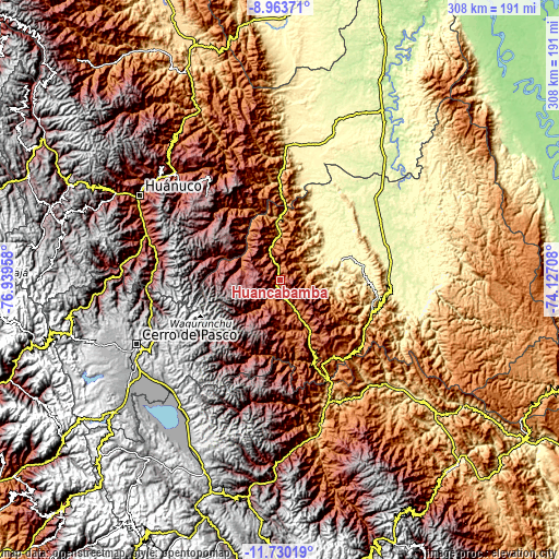
| \ | Map #1 | Topo.Map |
| Scale [m] | 1483..2978 m | × |
| Scale [ft] | 4865..9770 ft | × |
| Average | 2193.4 m = 7196 ft | × |
| Width | 9.61 km = 6 mi | 307.6 km = 191.1 mi |
| Height | 9.61 km = 6 mi | 307.6 km = 191.1 mi |
| ↑Max Latitude | -10.306767° | -8.96371° |
| Latitude at center | -10.35° | -10.35° |
| ↓Min Latitude | -10.393227° | -11.73019° |
| ← Min Longitude | -75.577275° | -76.93958° |
| Longitude center | -75.53333° | -75.53333° |
| →Max Longitude | -75.489385° | -74.12708° |
Nearby cities:
Cities around Huancabamba sort by population:
• Oxapampa elevation 1814 m
29.1 km,  150°
150°
• Villa Rica 1481 m
52 km, 146°
• Ambo 2098 m
77.4 km,  288°
288°
• Perené 612 m
74.3 km, 152°
• Paucartambo 3183 m
56 km,  212°
212°
• Pallanchacra 3124 m
77.1 km,  264°
264°
• Huariaca 2960 m
72.6 km, 261°
• Panao 2504 m
71.2 km,  314°
314°
• San Rafael 2720 m
71.1 km,  271°
271°
• Chaglla 3011 m
69.3 km,  324°
324°
• Pozuzo 1135 m
31.5 km,  0°
0°
• Chontabamba 2359 m
26.5 km,  168°
168°
Multilingual:
 En español:
Huancabamba elevación 1965 m.
 En France:
Huancabamba élévation 1965 m.
 Auf Deutsch:
Huancabamba höhe über dem Meeresspiegel ist 1965 m.

Sources and notes:
- [note 1] Map square and city borders are not equal. Map elevation data is calculated only from area inside that square.
- [src 1] Elevation data from geonames database provided with same terms of usage.
- [src 2] The elevation map of Huancabamba is generated using elevation data from NASA's 3 arcsec (90m) resolution SRTM data.
- [src 3] Base (background) map © OpenStreetMap contributors tiles are generated by Geofabrik and OpenTopoMap.
Copyright & License:
This Huancabamba Elevation Map is licensed under CC BY-SA. You may reuse any part from this page, if you give a proper credit by linking to this URL:
 More info on terms of use page.