Huariaca elevation
Huariaca (Pasco, Provincia de Pasco), Peru elevation is 2960 meters and Huariaca elevation in feet is 9711 ft above sea level [src 1]. Huariaca is a seat of a third-order administrative division (feature code) with elevation that is 639 meters (2096 ft) bigger than average city elevation in Peru.
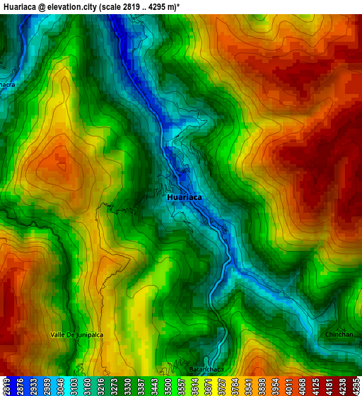
Below is the Elevation map of Huariaca, which displays elevation range with different colors. Scale of the first map is from 2819 to 4295 m (9249 to 14091 ft) with average elevation of 3563.1 meters (=11690 ft) [note 1]
These maps also provides idea of topography and contour of this city, they are displayed at different zoom levels. More info about maps, scale and edge coordinates you can find below images.
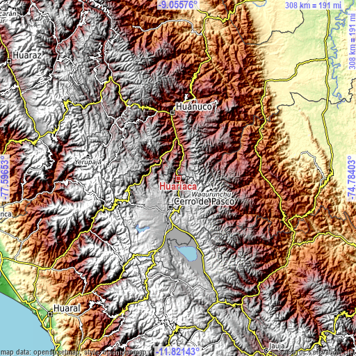
| \ | Map #1 | Topo.Map |
| Scale [m] | 2819..4295 m | × |
| Scale [ft] | 9249..14091 ft | × |
| Average | 3563.1 m = 11690 ft | × |
| Width | 9.61 km = 6 mi | 307.5 km = 191.1 mi |
| Height | 9.61 km = 6 mi | 307.5 km = 191.1 mi |
| ↑Max Latitude | -10.398449° | -9.05576° |
| Latitude at center | -10.44167° | -10.44167° |
| ↓Min Latitude | -10.484885° | -11.82143° |
| ← Min Longitude | -76.234225° | -77.59653° |
| Longitude center | -76.19028° | -76.19028° |
| →Max Longitude | -76.146335° | -74.78403° |
Nearby cities:
Cities around Huariaca sort by population:
• Cerro de Pasco elevation 4336 m
26.1 km,  196°
196°
• Chaupimarca 3446 m
29.9 km,  277°
277°
• Ambo 2098 m
34.6 km,  357°
357°
• Huacar 2117 m
31.7 km,  350°
350°
• Colpas 2693 m
31.1 km,  308°
308°
• Cayna 3332 m
28.8 km, 311°
• Paucar 3359 m
28.8 km,  285°
285°
• Vilcabamba 3444 m
28.4 km,  261°
261°
• Goyllarisquizga 4168 m
24.2 km, 261°
• Mosca 3471 m
15.6 km, 314°
• San Rafael 2720 m
11.5 km,  3°
3°
• Pallanchacra 3124 m
5.8 km,  300°
300°
Multilingual:
 En español:
Huariaca elevación 2960 m.
 En France:
Huariaca élévation 2960 m.
 Auf Deutsch:
Huariaca höhe über dem Meeresspiegel ist 2960 m.

Sources and notes:
- [note 1] Map square and city borders are not equal. Map elevation data is calculated only from area inside that square.
- [src 1] Elevation data from geonames database provided with same terms of usage.
- [src 2] The elevation map of Huariaca is generated using elevation data from NASA's 3 arcsec (90m) resolution SRTM data.
- [src 3] Base (background) map © OpenStreetMap contributors tiles are generated by Geofabrik and OpenTopoMap.
Copyright & License:
This Huariaca Elevation Map is licensed under CC BY-SA. You may reuse any part from this page, if you give a proper credit by linking to this URL:
 More info on terms of use page.