Colpas elevation
Colpas (Huanuco, Provincia de Ambo), Peru elevation is 2693 meters and Colpas elevation in feet is 8835 ft above sea level [src 1]. Colpas is a seat of a third-order administrative division (feature code) with elevation that is 372 meters (1220 ft) bigger than average city elevation in Peru.
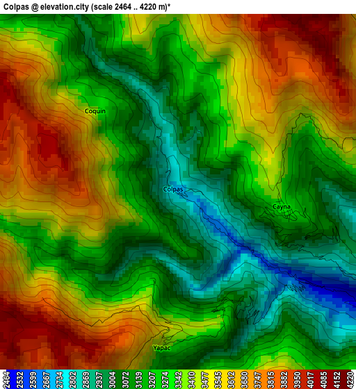
Below is the Elevation map of Colpas, which displays elevation range with different colors. Scale of the first map is from 2464 to 4220 m (8084 to 13845 ft) with average elevation of 3335.2 meters (=10942 ft) [note 1]
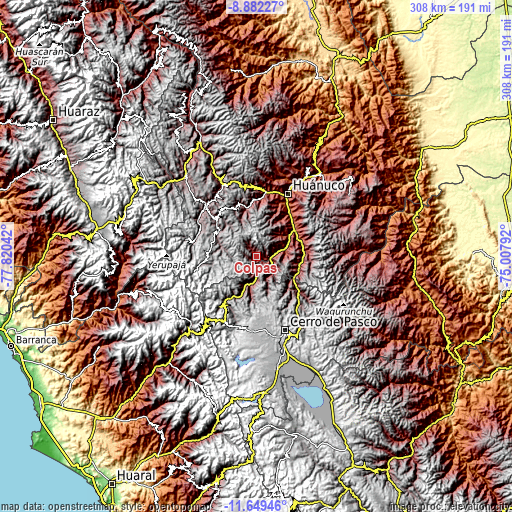
These maps also provides idea of topography and contour of this city, they are displayed at different zoom levels. More info about maps, scale and edge coordinates you can find below images.
| \ | Map #1 | Topo.Map |
| Scale [m] | 2464..4220 m | × |
| Scale [ft] | 8084..13845 ft | × |
| Average | 3335.2 m = 10942 ft | × |
| Width | 9.62 km = 6 mi | 307.7 km = 191.2 mi |
| Height | 9.62 km = 6 mi | 307.7 km = 191.2 mi |
| ↑Max Latitude | -10.225646° | -8.88227° |
| Latitude at center | -10.26889° | -10.26889° |
| ↓Min Latitude | -10.312128° | -11.64946° |
| ← Min Longitude | -76.458115° | -77.82042° |
| Longitude center | -76.41417° | -76.41417° |
| →Max Longitude | -76.370225° | -75.00792° |
Nearby cities:
Cities around Colpas sort by population:
• Chaupimarca elevation 3446 m
16.2 km,  198°
198°
• Yanacancha 3997 m
25.5 km,  276°
276°
• San Miguel de Cauri 3586 m
27.1 km,  302°
302°
• Cauri 3592 m
27 km, 301°
• San Rafael 2720 m
26.4 km,  106°
106°
• Pallanchacra 3124 m
25.4 km,  129°
129°
• Vilcabamba 3444 m
23.5 km,  188°
188°
• Goyllarisquizga 4168 m
22.8 km,  178°
178°
• Huacar 2117 m
22.8 km,  58°
58°
• Mosca 3471 m
15.7 km,  121°
121°
• Paucar 3359 m
11.8 km, 195°
• Cayna 3332 m
2.8 km,  96°
96°
Multilingual:
 En español:
Colpas elevación 2693 m.
 En France:
Colpas élévation 2693 m.


Sources and notes:
- [note 1] Map square and city borders are not equal. Map elevation data is calculated only from area inside that square.
- [src 1] Elevation data from geonames database provided with same terms of usage.
- [src 2] The elevation map of Colpas is generated using elevation data from NASA's 3 arcsec (90m) resolution SRTM data.
- [src 3] Base (background) map © OpenStreetMap contributors tiles are generated by Geofabrik and OpenTopoMap.
Copyright & License:
This Colpas Elevation Map is licensed under CC BY-SA. You may reuse any part from this page, if you give a proper credit by linking to this URL:
 More info on terms of use page.