San Miguel de Cauri elevation
San Miguel de Cauri (Huanuco, Lauricocha), Peru elevation is 3586 meters and San Miguel de Cauri elevation in feet is 11765 ft above sea level [src 1]. San Miguel de Cauri is a populated place (feature code) with elevation that is 1265 meters (4150 ft) bigger than average city elevation in Peru.
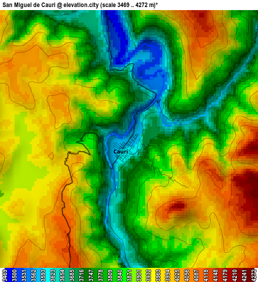
Below is the Elevation map of San Miguel de Cauri, which displays elevation range with different colors. Scale of the first map is from 3469 to 4272 m (11381 to 14016 ft) with average elevation of 3875.8 meters (=12716 ft) [note 1]
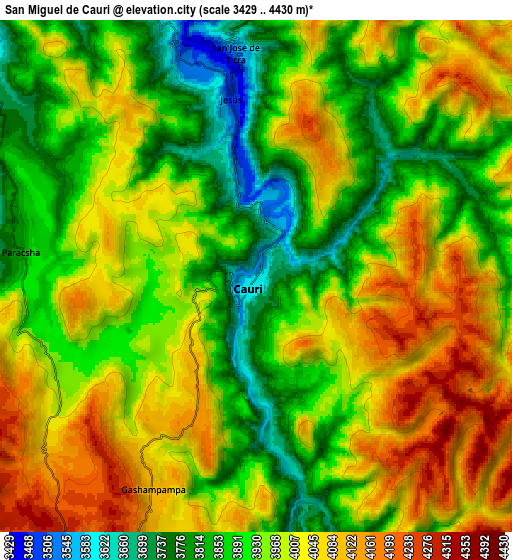
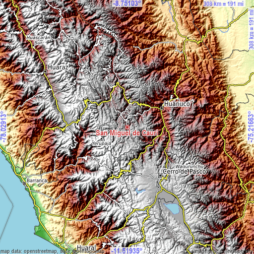
These maps also provides idea of topography and contour of this city, they are displayed at different zoom levels. More info about maps, scale and edge coordinates you can find below images.
| \ | Map #1 | Map #2 | Topo.Map |
| Scale [m] | 3469..4272 m | 3429..4430 m | × |
| Scale [ft] | 11381..14016 ft | 11250..14534 ft | × |
| Average | 3875.8 m = 12716 ft | 3959.3 m = 12990 ft | × |
| Width | 9.62 km = 6 mi | 19.24 km = 12 mi | 307.8 km = 191.3 mi |
| Height | 9.62 km = 6 mi | 19.24 km = 12 mi | 307.8 km = 191.3 mi |
| ↑Max Latitude | -10.094918° | -10.05165° | -8.75103° |
| Latitude at center | -10.13818° | -10.13818° | -10.13818° |
| ↓Min Latitude | -10.181436° | -10.224687° | -11.51935° |
| ← Min Longitude | -76.666825° | -76.710771° | -78.02913° |
| Longitude center | -76.62288° | -76.62288° | -76.62288° |
| →Max Longitude | -76.578935° | -76.534989° | -75.21663° |
Nearby cities:
Cities around San Miguel de Cauri sort by population:
• Yanacancha elevation 3997 m
11.7 km,  192°
192°
• Paucar 3359 m
32.5 km,  142°
142°
• Cahuac 3374 m
31.8 km,  358°
358°
• Chavinillo 3458 m
31.1 km,  2°
2°
• Cayna 3332 m
29.6 km,  120°
120°
• Colpas 2693 m
27.1 km, 122°
• Queropalca 3823 m
20.4 km,  256°
256°
• Rondos 3568 m
18.6 km,  337°
337°
• Margos 3541 m
18.3 km,  36°
36°
• Jivia 3354 m
14.1 km,  334°
334°
• Baños 3414 m
14.1 km,  299°
299°
• Cauri 3592 m
0.4 km,  207°
207°
Multilingual:
 En español:
San Miguel de Cauri elevación 3586 m.
 En France:
San Miguel de Cauri élévation 3586 m.
 Auf Deutsch:
San Miguel de Cauri höhe über dem Meeresspiegel ist 3586 m.
 На русском:
San Miguel de Cauri высота над уровнем моря 3586 м
Sources and notes:
- [note 1] Map square and city borders are not equal. Map elevation data is calculated only from area inside that square.
- [src 1] Elevation data from geonames database provided with same terms of usage.
- [src 2] The elevation map of San Miguel de Cauri is generated using elevation data from NASA's 3 arcsec (90m) resolution SRTM data.
- [src 3] Base (background) map © OpenStreetMap contributors tiles are generated by Geofabrik and OpenTopoMap.
Copyright & License:
This San Miguel de Cauri Elevation Map is licensed under CC BY-SA. You may reuse any part from this page, if you give a proper credit by linking to this URL:
 More info on terms of use page.