Perené elevation
Perené (Junin, Chanchamayo), Peru elevation is 612 meters and Perené elevation in feet is 2008 ft above sea level [src 1]. Perené is a populated place (feature code) with elevation that is 1709 meters (5607 ft) smaller than average city elevation in Peru.
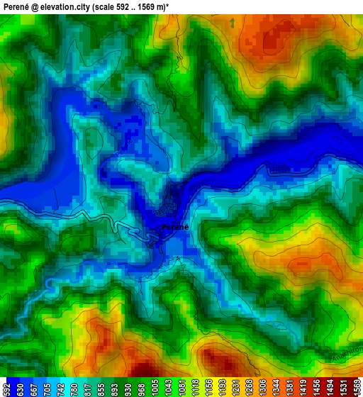
Below is the Elevation map of Perené, which displays elevation range with different colors. Scale of the first map is from 592 to 1569 m (1942 to 5148 ft) with average elevation of 922.7 meters (=3027 ft) [note 1]
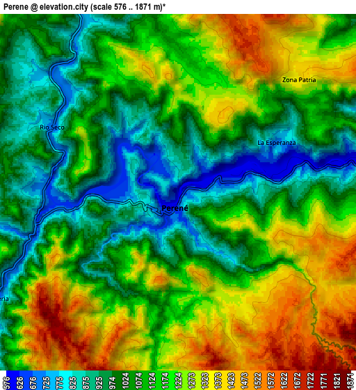
These maps also provides idea of topography and contour of this city, they are displayed at different zoom levels. More info about maps, scale and edge coordinates you can find below images.
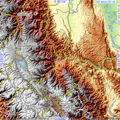
| \ | Map #1 | Map #2 | Topo.Map |
| Scale [m] | 592..1569 m | 576..1871 m | × |
| Scale [ft] | 1942..5148 ft | 1890..6138 ft | × |
| Average | 922.7 m = 3027 ft | 1133 m = 3717 ft | × |
| Width | 9.59 km = 6 mi | 19.19 km = 11.9 mi | 307 km = 190.8 mi |
| Height | 9.59 km = 6 mi | 19.19 km = 11.9 mi | 307 km = 190.8 mi |
| ↑Max Latitude | -10.901951° | -10.858796° | -9.56134° |
| Latitude at center | -10.9451° | -10.9451° | -10.9451° |
| ↓Min Latitude | -10.988243° | -11.031379° | -12.32242° |
| ← Min Longitude | -75.267885° | -75.311831° | -76.63019° |
| Longitude center | -75.22394° | -75.22394° | -75.22394° |
| →Max Longitude | -75.179995° | -75.136049° | -73.81769° |
Nearby cities:
Cities around Perené sort by population:
• San Ramón elevation 832 m
24.7 km,  216°
216°
• Oxapampa 1814 m
45.2 km,  334°
334°
• Villa Rica 1481 m
23.4 km,  347°
347°
• Huasahuasi 2737 m
58.3 km,  232°
232°
• Paucartambo 3183 m
66.9 km,  286°
286°
• Palcamayo 3338 m
71.5 km,  237°
237°
• Acobamba 2948 m
65.9 km, 226°
• Tapo 3134 m
61.9 km, 216°
• Palca 2738 m
58.3 km, 220°
• Chontabamba 2359 m
49.2 km,  324°
324°
• Bajo Pichanaqui 511 m
38.2 km,  87°
87°
• La Merced 750 m
17.7 km, 223°
Multilingual:
 En español:
Perené elevación 612 m.
 En France:
Perené élévation 612 m.


Sources and notes:
- [note 1] Map square and city borders are not equal. Map elevation data is calculated only from area inside that square.
- [src 1] Elevation data from geonames database provided with same terms of usage.
- [src 2] The elevation map of Perené is generated using elevation data from NASA's 3 arcsec (90m) resolution SRTM data.
- [src 3] Base (background) map © OpenStreetMap contributors tiles are generated by Geofabrik and OpenTopoMap.
Copyright & License:
This Perené Elevation Map is licensed under CC BY-SA. You may reuse any part from this page, if you give a proper credit by linking to this URL:
 More info on terms of use page.