Bajo Pichanaqui elevation
Bajo Pichanaqui (Junin, Chanchamayo), Peru elevation is 511 meters and Bajo Pichanaqui elevation in feet is 1677 ft above sea level [src 1]. Bajo Pichanaqui is a seat of a third-order administrative division (feature code) with elevation that is 1810 meters (5938 ft) smaller than average city elevation in Peru.
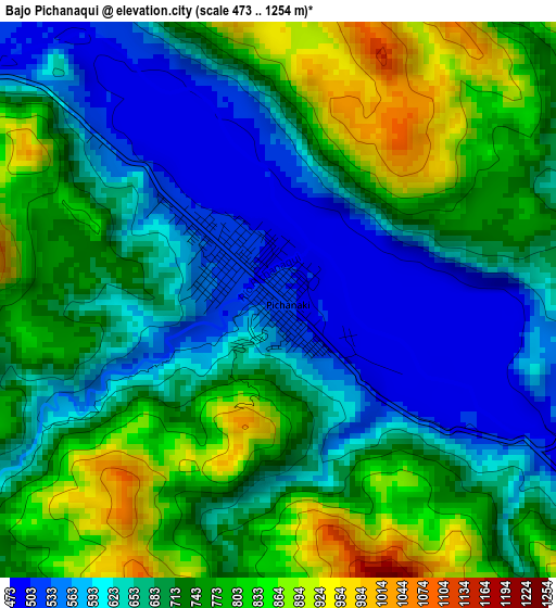
Below is the Elevation map of Bajo Pichanaqui, which displays elevation range with different colors. Scale of the first map is from 473 to 1254 m (1552 to 4114 ft) with average elevation of 704.8 meters (=2312 ft) [note 1]
These maps also provides idea of topography and contour of this city, they are displayed at different zoom levels. More info about maps, scale and edge coordinates you can find below images.
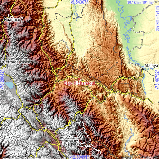
| \ | Map #1 | Topo.Map |
| Scale [m] | 473..1254 m | × |
| Scale [ft] | 1552..4114 ft | × |
| Average | 704.8 m = 2312 ft | × |
| Width | 9.6 km = 6 mi | 307 km = 190.8 mi |
| Height | 9.6 km = 6 mi | 307 km = 190.8 mi |
| ↑Max Latitude | -10.884348° | -9.54367° |
| Latitude at center | -10.9275° | -10.9275° |
| ↓Min Latitude | -10.970645° | -12.30491° |
| ← Min Longitude | -74.918115° | -76.28042° |
| Longitude center | -74.87417° | -74.87417° |
| →Max Longitude | -74.830225° | -73.46792° |
Nearby cities:
Cities around Bajo Pichanaqui sort by population:
• Satipo elevation 629 m
44.3 km,  144°
144°
• San Ramón 832 m
57.1 km,  247°
247°
• Oxapampa 1814 m
69.5 km,  304°
304°
• Villa Rica 1481 m
48 km, 295°
• Perené 612 m
38.2 km,  267°
267°
• Mazamari 665 m
58 km, 139°
• Mucllo 2493 m
80.1 km,  197°
197°
• Chontabamba 2359 m
76.8 km, 299°
• Puerto Ocopa 322 m
66.7 km,  111°
111°
• Mariposa 1223 m
54.5 km,  165°
165°
• La Merced 750 m
52.5 km, 253°
• Coviriali 677 m
48.7 km,  146°
146°
Multilingual:
 En español:
Bajo Pichanaqui elevación 511 m.
 En France:
Bajo Pichanaqui élévation 511 m.
 Auf Deutsch:
Bajo Pichanaqui höhe über dem Meeresspiegel ist 511 m.

Sources and notes:
- [note 1] Map square and city borders are not equal. Map elevation data is calculated only from area inside that square.
- [src 1] Elevation data from geonames database provided with same terms of usage.
- [src 2] The elevation map of Bajo Pichanaqui is generated using elevation data from NASA's 3 arcsec (90m) resolution SRTM data.
- [src 3] Base (background) map © OpenStreetMap contributors tiles are generated by Geofabrik and OpenTopoMap.
Copyright & License:
This Bajo Pichanaqui Elevation Map is licensed under CC BY-SA. You may reuse any part from this page, if you give a proper credit by linking to this URL:
 More info on terms of use page.