Chancay elevation
Chancay (Lima region, Provincia de Huaral), Peru elevation is 34 meters and Chancay elevation in feet is 112 ft above sea level [src 1]. Chancay is a seat of a third-order administrative division (feature code) with elevation that is 2287 meters (7503 ft) smaller than average city elevation in Peru.
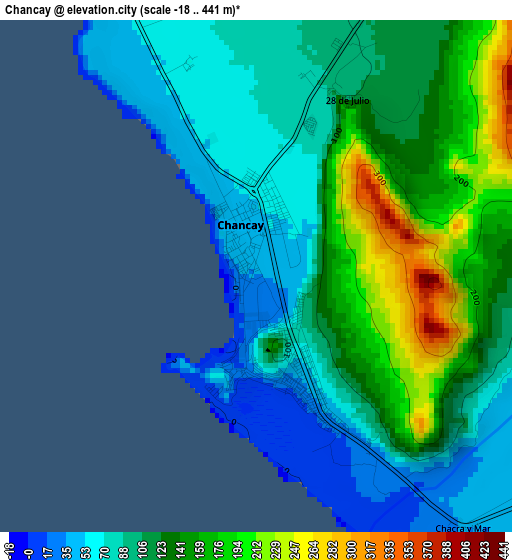
Below is the Elevation map of Chancay, which displays elevation range with different colors. Scale of the first map is from -18 to 441 m (-59 to 1447 ft) with average elevation of 114 meters (=374 ft) [note 1]
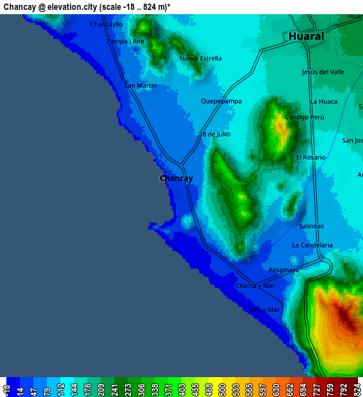
These maps also provides idea of topography and contour of this city, they are displayed at different zoom levels. More info about maps, scale and edge coordinates you can find below images.
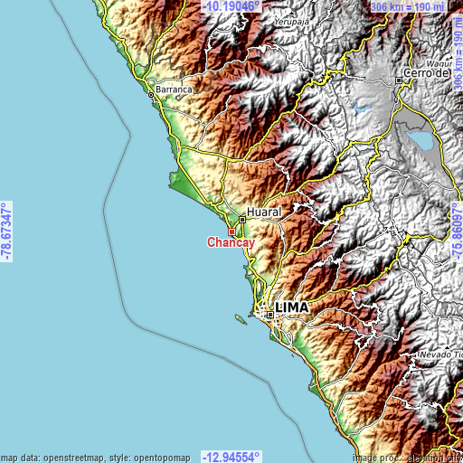
| \ | Map #1 | Map #2 | Topo.Map |
| Scale [m] | -18..441 m | -18..824 m | × |
| Scale [ft] | -59..1447 ft | -59..2703 ft | × |
| Average | 114 m = 374 ft | 155.6 m = 510 ft | × |
| Width | 9.57 km = 5.9 mi | 19.15 km = 11.9 mi | 306.3 km = 190.3 mi |
| Height | 9.57 km = 5.9 mi | 19.15 km = 11.9 mi | 306.4 km = 190.4 mi |
| ↑Max Latitude | -11.528335° | -11.485272° | -10.19046° |
| Latitude at center | -11.57139° | -11.57139° | -11.57139° |
| ↓Min Latitude | -11.614439° | -11.657481° | -12.94554° |
| ← Min Longitude | -77.311165° | -77.355111° | -78.67347° |
| Longitude center | -77.26722° | -77.26722° | -77.26722° |
| →Max Longitude | -77.223275° | -77.179329° | -75.86097° |
Nearby cities:
Cities around Chancay sort by population:
• Callao elevation 27 m
56.3 km,  163°
163°
• Huaral 183 m
10.7 km,  37°
37°
• Sayán 659 m
49.3 km,  9°
9°
• Urb. Santo Domingo 204 m
42.4 km,  143°
143°
• Independencia 164 m
52.4 km,  152°
152°
• Ihuari 2828 m
54.7 km, 39°
• Sumbilca 3367 m
52 km,  69°
69°
• Yangas 921 m
47.9 km,  106°
106°
• Carabayllo 234 m
40.1 km, 141°
• Ventanilla 128 m
37.5 km, 154°
• Santa Rosa 31 m
27.3 km, 158°
• Aucallama 140 m
9.5 km,  80°
80°
Multilingual:
 En español:
Chancay elevación 34 m.
 En France:
Chancay élévation 34 m.


Sources and notes:
- [note 1] Map square and city borders are not equal. Map elevation data is calculated only from area inside that square.
- [src 1] Elevation data from geonames database provided with same terms of usage.
- [src 2] The elevation map of Chancay is generated using elevation data from NASA's 3 arcsec (90m) resolution SRTM data.
- [src 3] Base (background) map © OpenStreetMap contributors tiles are generated by Geofabrik and OpenTopoMap.
Copyright & License:
This Chancay Elevation Map is licensed under CC BY-SA. You may reuse any part from this page, if you give a proper credit by linking to this URL:
 More info on terms of use page.