Yangas elevation
Yangas (Lima region, Provincia de Canta), Peru elevation is 921 meters and Yangas elevation in feet is 3022 ft above sea level [src 1]. Yangas is a seat of a third-order administrative division (feature code) with elevation that is 1400 meters (4593 ft) smaller than average city elevation in Peru.
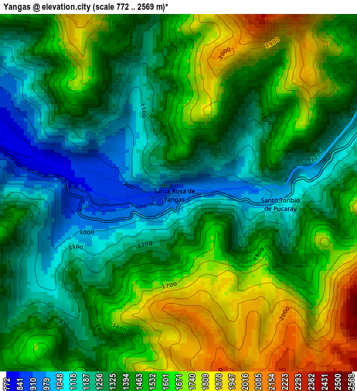
Below is the Elevation map of Yangas, which displays elevation range with different colors. Scale of the first map is from 772 to 2569 m (2533 to 8428 ft) with average elevation of 1441.7 meters (=4730 ft) [note 1]
These maps also provides idea of topography and contour of this city, they are displayed at different zoom levels. More info about maps, scale and edge coordinates you can find below images.
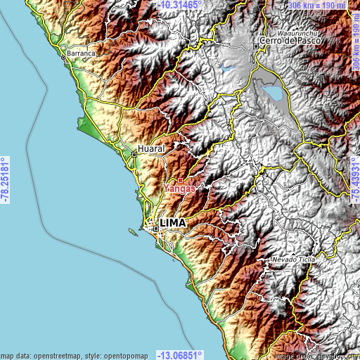
| \ | Map #1 | Topo.Map |
| Scale [m] | 772..2569 m | × |
| Scale [ft] | 2533..8428 ft | × |
| Average | 1441.7 m = 4730 ft | × |
| Width | 9.57 km = 5.9 mi | 306.2 km = 190.3 mi |
| Height | 9.57 km = 5.9 mi | 306.2 km = 190.3 mi |
| ↑Max Latitude | -11.651964° | -10.31465° |
| Latitude at center | -11.695° | -11.695° |
| ↓Min Latitude | -11.73803° | -13.06851° |
| ← Min Longitude | -76.889505° | -78.25181° |
| Longitude center | -76.84556° | -76.84556° |
| →Max Longitude | -76.801615° | -75.43931° |
Nearby cities:
Cities around Yangas sort by population:
• Chosica elevation 831 m
31.3 km,  151°
151°
• Asentamiento Humano Nicolas de Pierola 1016 m
30.8 km, 150°
• Urb. Santo Domingo 204 m
28.7 km,  225°
225°
• Ricardo Palma 1084 m
32.4 km,  140°
140°
• Sumbilca 3367 m
32.1 km,  4°
4°
• San Buenaventura 2707 m
30.4 km,  41°
41°
• Santa Eulalia 1030 m
30.3 km, 139°
• Callahuanca 1732 m
29 km,  120°
120°
• Lachaqui 3665 m
28.9 km,  56°
56°
• Carabayllo 234 m
27.3 km, 229°
• Huamantanga 3389 m
24.2 km,  25°
25°
• Arahuay 2559 m
20.8 km,  67°
67°
Multilingual:
 En español:
Yangas elevación 921 m.
 En France:
Yangas élévation 921 m.


Sources and notes:
- [note 1] Map square and city borders are not equal. Map elevation data is calculated only from area inside that square.
- [src 1] Elevation data from geonames database provided with same terms of usage.
- [src 2] The elevation map of Yangas is generated using elevation data from NASA's 3 arcsec (90m) resolution SRTM data.
- [src 3] Base (background) map © OpenStreetMap contributors tiles are generated by Geofabrik and OpenTopoMap.
Copyright & License:
This Yangas Elevation Map is licensed under CC BY-SA. You may reuse any part from this page, if you give a proper credit by linking to this URL:
 More info on terms of use page.