Lachaqui elevation
Lachaqui (Lima region, Provincia de Canta), Peru elevation is 3665 meters and Lachaqui elevation in feet is 12024 ft above sea level [src 1]. Lachaqui is a seat of a third-order administrative division (feature code) with elevation that is 1344 meters (4409 ft) bigger than average city elevation in Peru.
Below is the Elevation map of Lachaqui, which displays elevation range with different colors. Scale of the first map is from 2366 to 4675 m (7762 to 15338 ft) with average elevation of 3717.2 meters (=12196 ft) [note 1]
These maps also provides idea of topography and contour of this city, they are displayed at different zoom levels. More info about maps, scale and edge coordinates you can find below images.
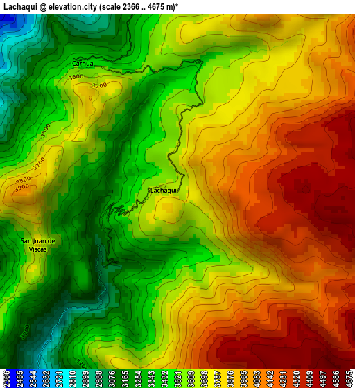
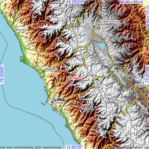
| \ | Map #1 | Topo.Map |
| Scale [m] | 2366..4675 m | × |
| Scale [ft] | 7762..15338 ft | × |
| Average | 3717.2 m = 12196 ft | × |
| Width | 9.57 km = 5.9 mi | 306.4 km = 190.4 mi |
| Height | 9.57 km = 5.9 mi | 306.4 km = 190.4 mi |
| ↑Max Latitude | -11.510272° | -10.17231° |
| Latitude at center | -11.55333° | -11.55333° |
| ↓Min Latitude | -11.596382° | -12.92757° |
| ← Min Longitude | -76.667275° | -78.02958° |
| Longitude center | -76.62333° | -76.62333° |
| →Max Longitude | -76.579385° | -75.21708° |
Nearby cities:
Cities around Lachaqui sort by population:
• Marcapomacocha elevation 4418 m
35.3 km,  62°
62°
• Callahuanca 1732 m
30.6 km,  178°
178°
• Yangas 921 m
28.9 km,  236°
236°
• Sumbilca 3367 m
26.9 km,  307°
307°
• Huanza 3391 m
17.4 km,  131°
131°
• Huaros 3586 m
17.2 km,  17°
17°
• Carampoma 3336 m
16.8 km,  135°
135°
• Laraos 3661 m
15.4 km, 143°
• Huamantanga 3389 m
14.9 km,  293°
293°
• Canta 2836 m
9.6 km,  359°
359°
• Arahuay 2559 m
9.2 km,  213°
213°
• San Buenaventura 2707 m
8.3 km,  329°
329°
Multilingual:
 En español:
Lachaqui elevación 3665 m.
 En France:
Lachaqui élévation 3665 m.
 Auf Deutsch:
Lachaqui höhe über dem Meeresspiegel ist 3665 m.

Sources and notes:
- [note 1] Map square and city borders are not equal. Map elevation data is calculated only from area inside that square.
- [src 1] Elevation data from geonames database provided with same terms of usage.
- [src 2] The elevation map of Lachaqui is generated using elevation data from NASA's 3 arcsec (90m) resolution SRTM data.
- [src 3] Base (background) map © OpenStreetMap contributors tiles are generated by Geofabrik and OpenTopoMap.
Copyright & License:
This Lachaqui Elevation Map is licensed under CC BY-SA. You may reuse any part from this page, if you give a proper credit by linking to this URL:
 More info on terms of use page.