Laraos elevation
Laraos (Lima region, Provincia de Huarochirí), Peru elevation is 3661 meters and Laraos elevation in feet is 12011 ft above sea level [src 1]. Laraos is a seat of a third-order administrative division (feature code) with elevation that is 1340 meters (4396 ft) bigger than average city elevation in Peru.
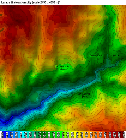
Below is the Elevation map of Laraos, which displays elevation range with different colors. Scale of the first map is from 2490 to 4859 m (8169 to 15942 ft) with average elevation of 3819.5 meters (=12531 ft) [note 1]
These maps also provides idea of topography and contour of this city, they are displayed at different zoom levels. More info about maps, scale and edge coordinates you can find below images.
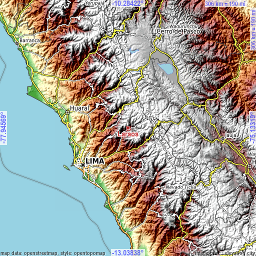
| \ | Map #1 | Topo.Map |
| Scale [m] | 2490..4859 m | × |
| Scale [ft] | 8169..15942 ft | × |
| Average | 3819.5 m = 12531 ft | × |
| Width | 9.57 km = 5.9 mi | 306.2 km = 190.3 mi |
| Height | 9.57 km = 5.9 mi | 306.3 km = 190.3 mi |
| ↑Max Latitude | -11.621679° | -10.28422° |
| Latitude at center | -11.66472° | -11.66472° |
| ↓Min Latitude | -11.707754° | -13.03838° |
| ← Min Longitude | -76.583385° | -77.94569° |
| Longitude center | -76.53944° | -76.53944° |
| →Max Longitude | -76.495495° | -75.13319° |
Nearby cities:
Cities around Laraos sort by population:
• Matucana elevation 2472 m
25.6 km,  143°
143°
• Huaros 3586 m
29.1 km,  351°
351°
• San Mateo 3159 m
28.1 km,  112°
112°
• Cocachacra 1470 m
27.6 km,  179°
179°
• Surco 2030 m
26.8 km,  156°
156°
• Canta 2836 m
23.8 km,  337°
337°
• San Buenaventura 2707 m
23.7 km,  325°
325°
• Callahuanca 1732 m
20 km,  204°
204°
• Lachaqui 3665 m
15.4 km,  323°
323°
• Arahuay 2559 m
14.9 km,  288°
288°
• Huanza 3391 m
4 km,  77°
77°
• Carampoma 3336 m
2.8 km, 80°
Multilingual:
 En español:
Laraos elevación 3661 m.
 En France:
Laraos élévation 3661 m.


Sources and notes:
- [note 1] Map square and city borders are not equal. Map elevation data is calculated only from area inside that square.
- [src 1] Elevation data from geonames database provided with same terms of usage.
- [src 2] The elevation map of Laraos is generated using elevation data from NASA's 3 arcsec (90m) resolution SRTM data.
- [src 3] Base (background) map © OpenStreetMap contributors tiles are generated by Geofabrik and OpenTopoMap.
Copyright & License:
This Laraos Elevation Map is licensed under CC BY-SA. You may reuse any part from this page, if you give a proper credit by linking to this URL:
 More info on terms of use page.