San Mateo elevation
San Mateo (Lima region, Provincia de Huarochirí), Peru elevation is 3159 meters and San Mateo elevation in feet is 10364 ft above sea level [src 1]. San Mateo is a seat of a third-order administrative division (feature code) with elevation that is 838 meters (2749 ft) bigger than average city elevation in Peru.
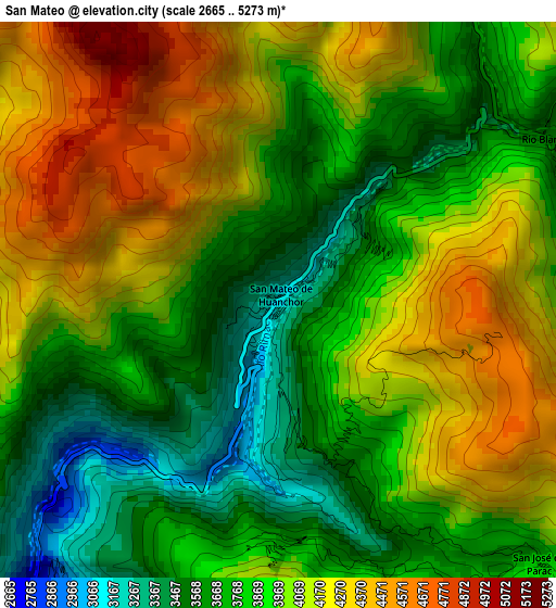
Below is the Elevation map of San Mateo, which displays elevation range with different colors. Scale of the first map is from 2665 to 5273 m (8743 to 17300 ft) with average elevation of 3943.7 meters (=12939 ft) [note 1]
These maps also provides idea of topography and contour of this city, they are displayed at different zoom levels. More info about maps, scale and edge coordinates you can find below images.
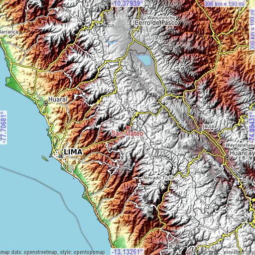
| \ | Map #1 | Topo.Map |
| Scale [m] | 2665..5273 m | × |
| Scale [ft] | 8743..17300 ft | × |
| Average | 3943.7 m = 12939 ft | × |
| Width | 9.57 km = 5.9 mi | 306.1 km = 190.2 mi |
| Height | 9.57 km = 5.9 mi | 306.2 km = 190.3 mi |
| ↑Max Latitude | -11.716414° | -10.37939° |
| Latitude at center | -11.75944° | -11.75944° |
| ↓Min Latitude | -11.80246° | -13.13261° |
| ← Min Longitude | -76.344505° | -77.70681° |
| Longitude center | -76.30056° | -76.30056° |
| →Max Longitude | -76.256615° | -74.89431° |
Nearby cities:
Cities around San Mateo sort by population:
• Morococha elevation 4512 m
24.8 km,  44°
44°
• Matucana 2472 m
14.8 km,  227°
227°
• Marcapomacocha 4418 m
39.4 km,  354°
354°
• Lahuaytambo 3067 m
39.4 km,  195°
195°
• Callahuanca 1732 m
35.2 km,  257°
257°
• Cocachacra 1470 m
31 km,  236°
236°
• Laraos 3661 m
28.1 km,  292°
292°
• Carampoma 3336 m
25.7 km,  295°
295°
• Yauli 4123 m
25.6 km,  65°
65°
• Huanza 3391 m
24.9 km, 297°
• Surco 2030 m
20.6 km, 227°
• Chicla 3697 m
6.9 km,  30°
30°
Multilingual:
 En español:
San Mateo elevación 3159 m.
 En France:
San Mateo élévation 3159 m.
 Auf Deutsch:
San Mateo höhe über dem Meeresspiegel ist 3159 m.

Sources and notes:
- [note 1] Map square and city borders are not equal. Map elevation data is calculated only from area inside that square.
- [src 1] Elevation data from geonames database provided with same terms of usage.
- [src 2] The elevation map of San Mateo is generated using elevation data from NASA's 3 arcsec (90m) resolution SRTM data.
- [src 3] Base (background) map © OpenStreetMap contributors tiles are generated by Geofabrik and OpenTopoMap.
Copyright & License:
This San Mateo Elevation Map is licensed under CC BY-SA. You may reuse any part from this page, if you give a proper credit by linking to this URL:
 More info on terms of use page.