Matucana elevation
Matucana (Lima region, Provincia de Huarochirí), Peru elevation is 2472 meters and Matucana elevation in feet is 8110 ft above sea level [src 1]. Matucana is a seat of a third-order administrative division (feature code) with elevation that is 151 meters (495 ft) bigger than average city elevation in Peru.
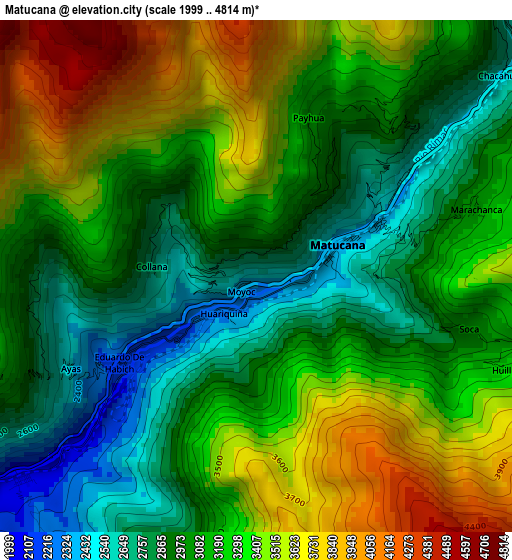
Below is the Elevation map of Matucana, which displays elevation range with different colors. Scale of the first map is from 1999 to 4814 m (6558 to 15794 ft) with average elevation of 3183.2 meters (=10444 ft) [note 1]
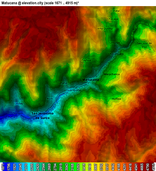
These maps also provides idea of topography and contour of this city, they are displayed at different zoom levels. More info about maps, scale and edge coordinates you can find below images.
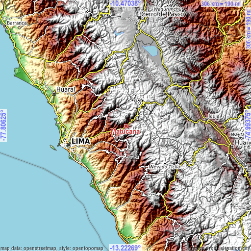
| \ | Map #1 | Map #2 | Topo.Map |
| Scale [m] | 1999..4814 m | 1671..4915 m | × |
| Scale [ft] | 6558..15794 ft | 5482..16125 ft | × |
| Average | 3183.2 m = 10444 ft | 3689.8 m = 12106 ft | × |
| Width | 9.56 km = 5.9 mi | 19.13 km = 11.9 mi | 306 km = 190.1 mi |
| Height | 9.56 km = 5.9 mi | 19.13 km = 11.9 mi | 306.1 km = 190.2 mi |
| ↑Max Latitude | -11.806988° | -11.763969° | -10.47038° |
| Latitude at center | -11.85° | -11.85° | -11.85° |
| ↓Min Latitude | -11.893005° | -11.936004° | -13.22269° |
| ← Min Longitude | -76.443945° | -76.487891° | -77.80625° |
| Longitude center | -76.4° | -76.4° | -76.4° |
| →Max Longitude | -76.356055° | -76.312109° | -74.99375° |
Nearby cities:
Cities around Matucana sort by population:
• Asentamiento Humano Nicolas de Pierola elevation 1016 m
34.6 km,  254°
254°
• Ricardo Palma 1084 m
28.9 km, 254°
• Santa Eulalia 1030 m
29.2 km,  258°
258°
• Lahuaytambo 3067 m
27.8 km,  180°
180°
• Laraos 3661 m
25.6 km,  323°
323°
• Carampoma 3336 m
24.4 km,  329°
329°
• Huanza 3391 m
24.3 km, 332°
• Callahuanca 1732 m
23.7 km,  275°
275°
• Chicla 3697 m
21.5 km,  41°
41°
• Cocachacra 1470 m
16.6 km,  244°
244°
• San Mateo 3159 m
14.8 km,  47°
47°
• Surco 2030 m
5.8 km,  228°
228°
Multilingual:
 En español:
Matucana elevación 2472 m.
 En France:
Matucana élévation 2472 m.
 Auf Deutsch:
Matucana höhe über dem Meeresspiegel ist 2472 m.

Sources and notes:
- [note 1] Map square and city borders are not equal. Map elevation data is calculated only from area inside that square.
- [src 1] Elevation data from geonames database provided with same terms of usage.
- [src 2] The elevation map of Matucana is generated using elevation data from NASA's 3 arcsec (90m) resolution SRTM data.
- [src 3] Base (background) map © OpenStreetMap contributors tiles are generated by Geofabrik and OpenTopoMap.
Copyright & License:
This Matucana Elevation Map is licensed under CC BY-SA. You may reuse any part from this page, if you give a proper credit by linking to this URL:
 More info on terms of use page.