Callao elevation
Callao, Peru elevation is 27 meters and Callao elevation in feet is 89 ft above sea level [src 1]. Callao is a seat of a first-order administrative division (feature code) with elevation that is 2294 meters (7526 ft) smaller than average city elevation in Peru.
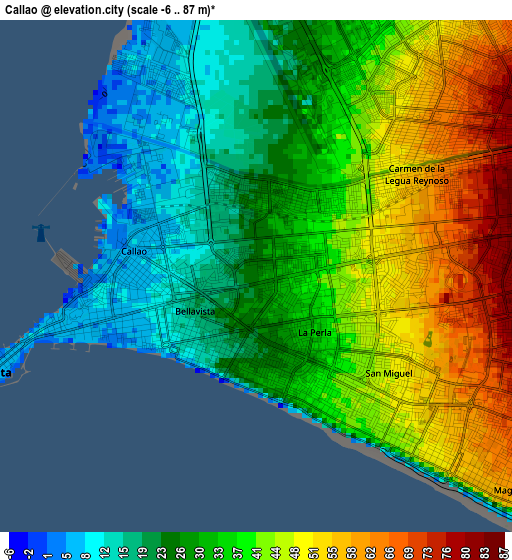
Below is the Elevation map of Callao, which displays elevation range with different colors. Scale of the first map is from -6 to 87 m (-20 to 285 ft) with average elevation of 35.6 meters (=117 ft) [note 1]
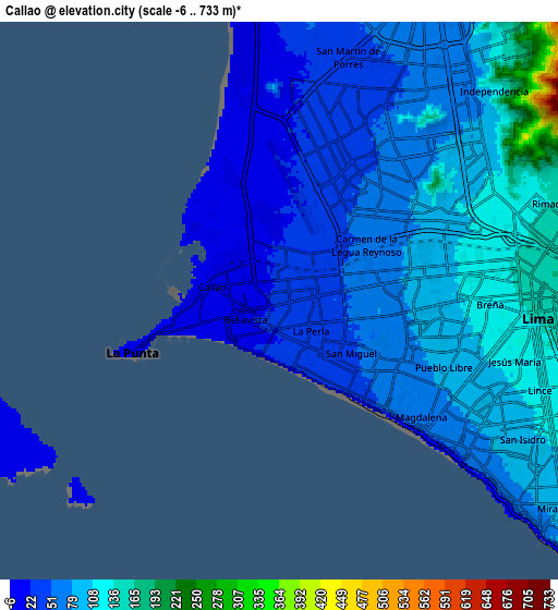
These maps also provides idea of topography and contour of this city, they are displayed at different zoom levels. More info about maps, scale and edge coordinates you can find below images.
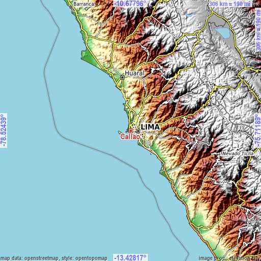
| \ | Map #1 | Map #2 | Topo.Map |
| Scale [m] | -6..87 m | -6..733 m | × |
| Scale [ft] | -20..285 ft | -20..2405 ft | × |
| Average | 35.6 m = 117 ft | 75.1 m = 246 ft | × |
| Width | 9.56 km = 5.9 mi | 19.11 km = 11.9 mi | 305.8 km = 190 mi |
| Height | 9.56 km = 5.9 mi | 19.11 km = 11.9 mi | 305.8 km = 190 mi |
| ↑Max Latitude | -12.013611° | -11.970624° | -10.67796° |
| Latitude at center | -12.05659° | -12.05659° | -12.05659° |
| ↓Min Latitude | -12.099563° | -12.142528° | -13.42817° |
| ← Min Longitude | -77.162085° | -77.206031° | -78.52439° |
| Longitude center | -77.11814° | -77.11814° | -77.11814° |
| →Max Longitude | -77.074195° | -77.030249° | -75.71189° |
Nearby cities:
Cities around Callao sort by population:
• Lima elevation 152 m
9.9 km,  81°
81°
• Santiago de Surco 92 m
14.9 km,  126°
126°
• San Isidro 6 m
10 km, 132°
• Santa María 545 m
25.1 km, 76°
• San Luis 191 m
13.6 km,  99°
99°
• Urb. Santo Domingo 204 m
22 km,  24°
24°
• Independencia 164 m
10.8 km,  46°
46°
• Santa Rosa 31 m
29.2 km,  348°
348°
• Carabayllo 234 m
24.2 km, 21°
• Vitarte 330 m
20.3 km, 82°
• Ventanilla 128 m
20.2 km,  359°
359°
• La Molina 236 m
18.5 km, 99°
Multilingual:
 En español:
El Callao elevación 27 m.
 En France:
Callao élévation 27 m.


Sources and notes:
- [note 1] Map square and city borders are not equal. Map elevation data is calculated only from area inside that square.
- [src 1] Elevation data from geonames database provided with same terms of usage.
- [src 2] The elevation map of Callao is generated using elevation data from NASA's 3 arcsec (90m) resolution SRTM data.
- [src 3] Base (background) map © OpenStreetMap contributors tiles are generated by Geofabrik and OpenTopoMap.
Copyright & License:
This Callao Elevation Map is licensed under CC BY-SA. You may reuse any part from this page, if you give a proper credit by linking to this URL:
 More info on terms of use page.