Santa Rosa elevation
Santa Rosa (Lima region, Lima), Peru elevation is 31 meters and Santa Rosa elevation in feet is 102 ft above sea level [src 1]. Santa Rosa is a seat of a third-order administrative division (feature code) with elevation that is 2290 meters (7513 ft) smaller than average city elevation in Peru.
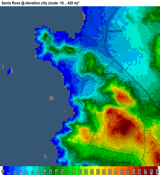
Below is the Elevation map of Santa Rosa, which displays elevation range with different colors. Scale of the first map is from -10 to 420 m (-33 to 1378 ft) with average elevation of 124 meters (=407 ft) [note 1]
These maps also provides idea of topography and contour of this city, they are displayed at different zoom levels. More info about maps, scale and edge coordinates you can find below images.
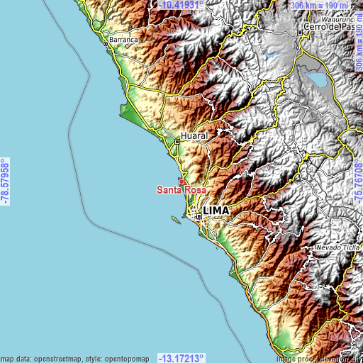
| \ | Map #1 | Topo.Map |
| Scale [m] | -10..420 m | × |
| Scale [ft] | -33..1378 ft | × |
| Average | 124 m = 407 ft | × |
| Width | 9.57 km = 5.9 mi | 306.1 km = 190.2 mi |
| Height | 9.57 km = 5.9 mi | 306.1 km = 190.2 mi |
| ↑Max Latitude | -11.75615° | -10.41931° |
| Latitude at center | -11.79917° | -11.79917° |
| ↓Min Latitude | -11.842183° | -13.17213° |
| ← Min Longitude | -77.217275° | -78.57958° |
| Longitude center | -77.17333° | -77.17333° |
| →Max Longitude | -77.129385° | -75.76708° |
Nearby cities:
Cities around Santa Rosa sort by population:
• Lima elevation 152 m
31.4 km,  149°
149°
• Callao 27 m
29.2 km,  168°
168°
• Huaral 183 m
34 km,  353°
353°
• Chancay 34 m
27.3 km,  338°
338°
• San Luis 191 m
36.5 km, 147°
• Urb. Santo Domingo 204 m
17.5 km,  119°
119°
• Independencia 164 m
25.4 km, 146°
• Yangas 921 m
37.5 km,  72°
72°
• Vitarte 330 m
36.9 km,  134°
134°
• Aucallama 140 m
26.9 km,  358°
358°
• Carabayllo 234 m
15.9 km,  112°
112°
• Ventanilla 128 m
10.4 km,  144°
144°
Multilingual:
 En español:
Santa Rosa elevación 31 m.
 En France:
Santa Rosa élévation 31 m.
 Auf Deutsch:
Santa Rosa höhe über dem Meeresspiegel ist 31 m.

Sources and notes:
- [note 1] Map square and city borders are not equal. Map elevation data is calculated only from area inside that square.
- [src 1] Elevation data from geonames database provided with same terms of usage.
- [src 2] The elevation map of Santa Rosa is generated using elevation data from NASA's 3 arcsec (90m) resolution SRTM data.
- [src 3] Base (background) map © OpenStreetMap contributors tiles are generated by Geofabrik and OpenTopoMap.
Copyright & License:
This Santa Rosa Elevation Map is licensed under CC BY-SA. You may reuse any part from this page, if you give a proper credit by linking to this URL:
 More info on terms of use page.