Sayán elevation
Sayán (Lima region, Huaura), Peru elevation is 659 meters and Sayán elevation in feet is 2162 ft above sea level [src 1]. Sayán is a populated place (feature code) with elevation that is 1662 meters (5453 ft) smaller than average city elevation in Peru.
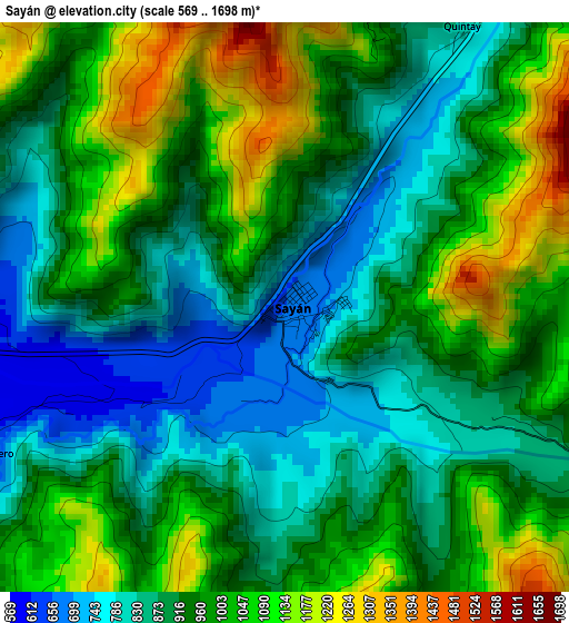
Below is the Elevation map of Sayán, which displays elevation range with different colors. Scale of the first map is from 569 to 1698 m (1867 to 5571 ft) with average elevation of 951.4 meters (=3121 ft) [note 1]
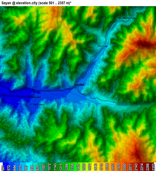
These maps also provides idea of topography and contour of this city, they are displayed at different zoom levels. More info about maps, scale and edge coordinates you can find below images.
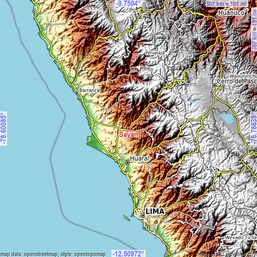
| \ | Map #1 | Map #2 | Topo.Map |
| Scale [m] | 569..1698 m | 501..2357 m | × |
| Scale [ft] | 1867..5571 ft | 1644..7733 ft | × |
| Average | 951.4 m = 3121 ft | 1166 m = 3825 ft | × |
| Width | 9.59 km = 6 mi | 19.18 km = 11.9 mi | 306.8 km = 190.6 mi |
| Height | 9.59 km = 6 mi | 19.18 km = 11.9 mi | 306.8 km = 190.6 mi |
| ↑Max Latitude | -11.090209° | -11.047081° | -9.7504° |
| Latitude at center | -11.13333° | -11.13333° | -11.13333° |
| ↓Min Latitude | -11.176445° | -11.219554° | -12.50972° |
| ← Min Longitude | -77.238545° | -77.282491° | -78.60085° |
| Longitude center | -77.1946° | -77.1946° | -77.1946° |
| →Max Longitude | -77.150655° | -77.106709° | -75.78835° |
Nearby cities:
Cities around Sayán sort by population:
• Huaral elevation 183 m
40.2 km,  182°
182°
• Huacho 41 m
44.9 km,  273°
273°
• Huaura 72 m
44.7 km,  279°
279°
• Ambar 2736 m
45.2 km,  349°
349°
• Maray 3695 m
45.1 km,  60°
60°
• Cruz Blanca 64 m
43.6 km, 275°
• Acos 1583 m
43.6 km,  110°
110°
• Caujul 3168 m
43.4 km,  32°
32°
• Lampian 2433 m
40.4 km, 106°
• Paccho 3259 m
34.7 km, 55°
• Santa Cruz 3277 m
30 km,  74°
74°
• Ihuari 2828 m
27.2 km,  103°
103°
Multilingual:
 En español:
Sayán elevación 659 m.
 En France:
Sayán élévation 659 m.


Sources and notes:
- [note 1] Map square and city borders are not equal. Map elevation data is calculated only from area inside that square.
- [src 1] Elevation data from geonames database provided with same terms of usage.
- [src 2] The elevation map of Sayán is generated using elevation data from NASA's 3 arcsec (90m) resolution SRTM data.
- [src 3] Base (background) map © OpenStreetMap contributors tiles are generated by Geofabrik and OpenTopoMap.
Copyright & License:
This Sayán Elevation Map is licensed under CC BY-SA. You may reuse any part from this page, if you give a proper credit by linking to this URL:
 More info on terms of use page.