Uripa elevation
Uripa (Apurímac, Chincheros), Peru elevation is 3209 meters and Uripa elevation in feet is 10528 ft above sea level [src 1]. Uripa is a seat of a third-order administrative division (feature code) with elevation that is 888 meters (2913 ft) bigger than average city elevation in Peru.
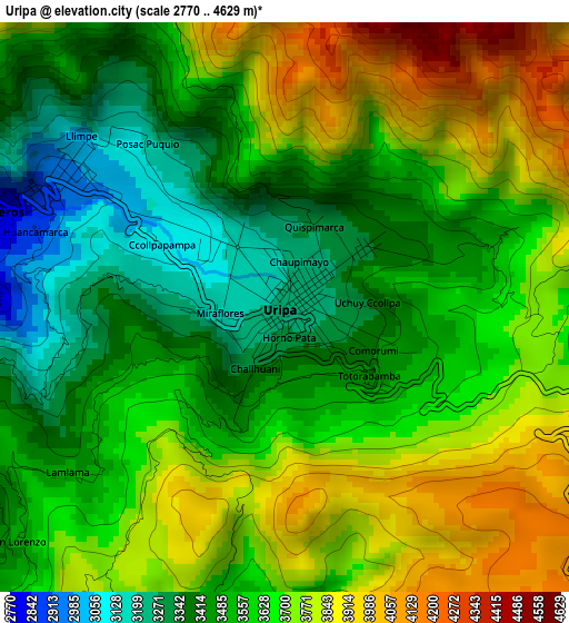
Below is the Elevation map of Uripa, which displays elevation range with different colors. Scale of the first map is from 2770 to 4629 m (9088 to 15187 ft) with average elevation of 3609.9 meters (=11844 ft) [note 1]
These maps also provides idea of topography and contour of this city, they are displayed at different zoom levels. More info about maps, scale and edge coordinates you can find below images.
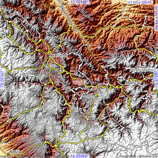
| \ | Map #1 | Topo.Map |
| Scale [m] | 2770..4629 m | × |
| Scale [ft] | 9088..15187 ft | × |
| Average | 3609.9 m = 11844 ft | × |
| Width | 9.5 km = 5.9 mi | 304 km = 188.9 mi |
| Height | 9.5 km = 5.9 mi | 304 km = 188.9 mi |
| ↑Max Latitude | -13.489771° | -12.16149° |
| Latitude at center | -13.5325° | -13.5325° |
| ↓Min Latitude | -13.575221° | -14.89566° |
| ← Min Longitude | -73.721165° | -75.08347° |
| Longitude center | -73.67722° | -73.67722° |
| →Max Longitude | -73.633275° | -72.27097° |
Nearby cities:
Cities around Uripa sort by population:
• Talavera elevation 2826 m
30 km,  116°
116°
• Andarapa 2914 m
33.6 km,  88°
88°
• Ocros 3130 m
30.1 km,  301°
301°
• Huancaray 2917 m
29.9 km,  147°
147°
• Carhuanca 2964 m
26.3 km,  207°
207°
• Saurama 3573 m
20 km, 206°
• Huaccana 3078 m
16.2 km,  355°
355°
• Ongoy 2805 m
14.4 km,  3°
3°
• Ocobamba 3005 m
13.8 km,  65°
65°
• Cocharcas 3022 m
11 km,  218°
218°
• Ranracancha 3394 m
7.8 km, 90°
• Chincheros 2781 m
5.1 km,  287°
287°
Multilingual:
 En español:
Uripa elevación 3209 m.
 En France:
Uripa élévation 3209 m.


Sources and notes:
- [note 1] Map square and city borders are not equal. Map elevation data is calculated only from area inside that square.
- [src 1] Elevation data from geonames database provided with same terms of usage.
- [src 2] The elevation map of Uripa is generated using elevation data from NASA's 3 arcsec (90m) resolution SRTM data.
- [src 3] Base (background) map © OpenStreetMap contributors tiles are generated by Geofabrik and OpenTopoMap.
Copyright & License:
This Uripa Elevation Map is licensed under CC BY-SA. You may reuse any part from this page, if you give a proper credit by linking to this URL:
 More info on terms of use page.