Ocros elevation
Ocros (Ayacucho, Provincia de Huamanga), Peru elevation is 3130 meters and Ocros elevation in feet is 10269 ft above sea level [src 1]. Ocros is a seat of a third-order administrative division (feature code) with elevation that is 809 meters (2654 ft) bigger than average city elevation in Peru.
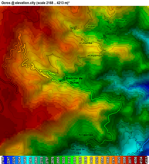
Below is the Elevation map of Ocros, which displays elevation range with different colors. Scale of the first map is from 2168 to 4213 m (7113 to 13822 ft) with average elevation of 3352 meters (=10997 ft) [note 1]
These maps also provides idea of topography and contour of this city, they are displayed at different zoom levels. More info about maps, scale and edge coordinates you can find below images.
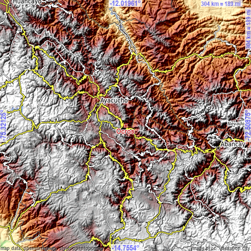
| \ | Map #1 | Topo.Map |
| Scale [m] | 2168..4213 m | × |
| Scale [ft] | 7113..13822 ft | × |
| Average | 3352 m = 10997 ft | × |
| Width | 9.51 km = 5.9 mi | 304.2 km = 189 mi |
| Height | 9.51 km = 5.9 mi | 304.2 km = 189 mi |
| ↑Max Latitude | -13.348636° | -12.01961° |
| Latitude at center | -13.39139° | -13.39139° |
| ↓Min Latitude | -13.434137° | -14.7554° |
| ← Min Longitude | -73.958945° | -75.32125° |
| Longitude center | -73.915° | -73.915° |
| →Max Longitude | -73.871055° | -72.50875° |
Nearby cities:
Cities around Ocros sort by population:
• Pampa Cangallo elevation 3311 m
35.6 km,  238°
238°
• Chiara 3506 m
34 km,  292°
292°
• Cocharcas 3022 m
30.8 km,  142°
142°
• Tambillo 3081 m
30.7 km,  316°
316°
• Uripa 3209 m
30.1 km,  121°
121°
• Ongoy 2805 m
26.6 km,  92°
92°
• Chincheros 2781 m
25.2 km, 124°
• Chilcas 3192 m
24.5 km,  2°
2°
• Huaccana 3078 m
24.4 km, 88°
• Acocro 3251 m
23.8 km, 324°
• Vischongo 3114 m
23.6 km,  201°
201°
• Pampas 2953 m
18.2 km,  7°
7°
Multilingual:
 En español:
Ocros elevación 3130 m.
 En France:
Ocros élévation 3130 m.


Sources and notes:
- [note 1] Map square and city borders are not equal. Map elevation data is calculated only from area inside that square.
- [src 1] Elevation data from geonames database provided with same terms of usage.
- [src 2] The elevation map of Ocros is generated using elevation data from NASA's 3 arcsec (90m) resolution SRTM data.
- [src 3] Base (background) map © OpenStreetMap contributors tiles are generated by Geofabrik and OpenTopoMap.
Copyright & License:
This Ocros Elevation Map is licensed under CC BY-SA. You may reuse any part from this page, if you give a proper credit by linking to this URL:
 More info on terms of use page.