Ocobamba elevation
Ocobamba (Apurímac, Chincheros), Peru elevation is 3005 meters and Ocobamba elevation in feet is 9859 ft above sea level [src 1]. Ocobamba is a seat of a third-order administrative division (feature code) with elevation that is 684 meters (2244 ft) bigger than average city elevation in Peru.
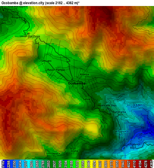
Below is the Elevation map of Ocobamba, which displays elevation range with different colors. Scale of the first map is from 2182 to 4362 m (7159 to 14311 ft) with average elevation of 3363.3 meters (=11034 ft) [note 1]
These maps also provides idea of topography and contour of this city, they are displayed at different zoom levels. More info about maps, scale and edge coordinates you can find below images.
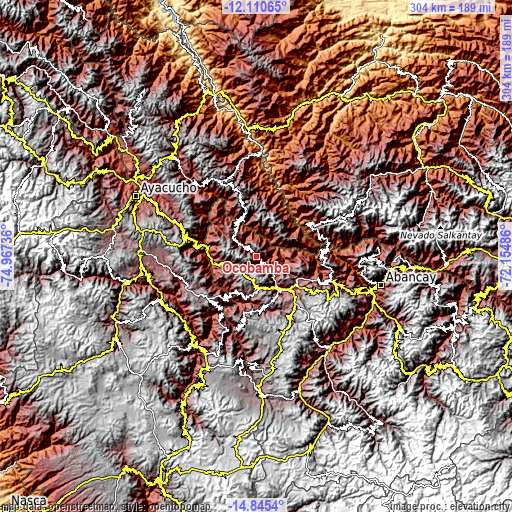
| \ | Map #1 | Topo.Map |
| Scale [m] | 2182..4362 m | × |
| Scale [ft] | 7159..14311 ft | × |
| Average | 3363.3 m = 11034 ft | × |
| Width | 9.5 km = 5.9 mi | 304.1 km = 189 mi |
| Height | 9.5 km = 5.9 mi | 304.1 km = 189 mi |
| ↑Max Latitude | -13.439202° | -12.11065° |
| Latitude at center | -13.48194° | -13.48194° |
| ↓Min Latitude | -13.524671° | -14.8454° |
| ← Min Longitude | -73.605055° | -74.96736° |
| Longitude center | -73.56111° | -73.56111° |
| →Max Longitude | -73.517165° | -72.15486° |
Nearby cities:
Cities around Ocobamba sort by population:
• Andahuaylas elevation 2902 m
26.9 km,  135°
135°
• Talavera 2826 m
23.8 km, 143°
• San Jerónimo 2958 m
28.4 km,  131°
131°
• Chungui 3566 m
29.9 km,  347°
347°
• Pacucha 3132 m
27.4 km,  120°
120°
• Cocharcas 3022 m
24 km,  233°
233°
• Andarapa 2914 m
21.6 km,  103°
103°
• Chincheros 2781 m
17.9 km,  256°
256°
• Huaccana 3078 m
17.4 km,  307°
307°
• Ongoy 2805 m
14.6 km, 306°
• Uripa 3209 m
13.8 km,  245°
245°
• Ranracancha 3394 m
7.5 km,  219°
219°
Multilingual:
 En español:
Ocobamba elevación 3005 m.
 En France:
Ocobamba élévation 3005 m.
 Auf Deutsch:
Ocobamba höhe über dem Meeresspiegel ist 3005 m.

Sources and notes:
- [note 1] Map square and city borders are not equal. Map elevation data is calculated only from area inside that square.
- [src 1] Elevation data from geonames database provided with same terms of usage.
- [src 2] The elevation map of Ocobamba is generated using elevation data from NASA's 3 arcsec (90m) resolution SRTM data.
- [src 3] Base (background) map © OpenStreetMap contributors tiles are generated by Geofabrik and OpenTopoMap.
Copyright & License:
This Ocobamba Elevation Map is licensed under CC BY-SA. You may reuse any part from this page, if you give a proper credit by linking to this URL:
 More info on terms of use page.