Saurama elevation
Saurama (Ayacucho, Provincia de Vilcas Huamán), Peru elevation is 3573 meters and Saurama elevation in feet is 11722 ft above sea level [src 1]. Saurama is a seat of a third-order administrative division (feature code) with elevation that is 1252 meters (4108 ft) bigger than average city elevation in Peru.
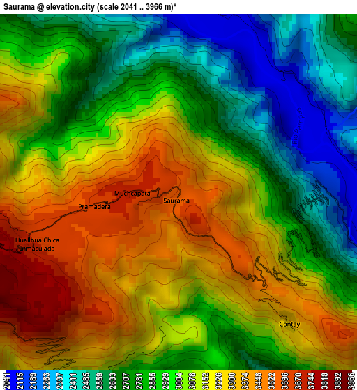
Below is the Elevation map of Saurama, which displays elevation range with different colors. Scale of the first map is from 2041 to 3966 m (6696 to 13012 ft) with average elevation of 3005.8 meters (=9862 ft) [note 1]
These maps also provides idea of topography and contour of this city, they are displayed at different zoom levels. More info about maps, scale and edge coordinates you can find below images.
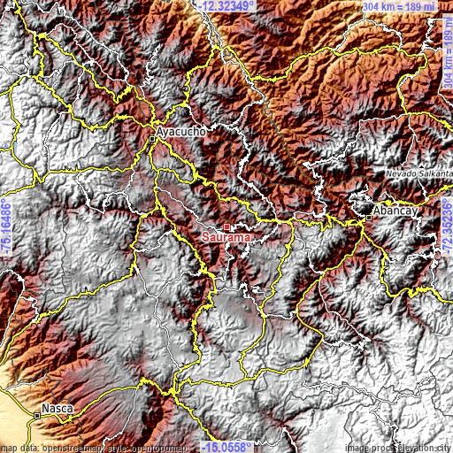
| \ | Map #1 | Topo.Map |
| Scale [m] | 2041..3966 m | × |
| Scale [ft] | 6696..13012 ft | × |
| Average | 3005.8 m = 9862 ft | × |
| Width | 9.49 km = 5.9 mi | 303.8 km = 188.8 mi |
| Height | 9.49 km = 5.9 mi | 303.8 km = 188.8 mi |
| ↑Max Latitude | -13.65091° | -12.32349° |
| Latitude at center | -13.69361° | -13.69361° |
| ↓Min Latitude | -13.736302° | -15.0558° |
| ← Min Longitude | -73.802555° | -75.16486° |
| Longitude center | -73.75861° | -73.75861° |
| →Max Longitude | -73.714665° | -72.35236° |
Nearby cities:
Cities around Saurama sort by population:
• Vischongo elevation 3114 m
28 km,  294°
294°
• Cayara 3191 m
27.3 km,  245°
245°
• Huancaray 2917 m
26 km,  106°
106°
• Ranracancha 3394 m
24.3 km,  42°
42°
• Chiara 3326 m
21.8 km,  153°
153°
• Uripa 3209 m
20 km,  26°
26°
• Chincheros 2781 m
19.9 km,  11°
11°
• Huambalpa 3289 m
19.6 km, 251°
• Accomarca 3381 m
19.6 km,  232°
232°
• Chalcos 3650 m
17.2 km,  178°
178°
• Cocharcas 3022 m
9.5 km, 12°
• Carhuanca 2964 m
6.3 km,  210°
210°
Multilingual:
 En español:
Saurama elevación 3573 m.
 En France:
Saurama élévation 3573 m.
 Auf Deutsch:
Saurama höhe über dem Meeresspiegel ist 3573 m.

Sources and notes:
- [note 1] Map square and city borders are not equal. Map elevation data is calculated only from area inside that square.
- [src 1] Elevation data from geonames database provided with same terms of usage.
- [src 2] The elevation map of Saurama is generated using elevation data from NASA's 3 arcsec (90m) resolution SRTM data.
- [src 3] Base (background) map © OpenStreetMap contributors tiles are generated by Geofabrik and OpenTopoMap.
Copyright & License:
This Saurama Elevation Map is licensed under CC BY-SA. You may reuse any part from this page, if you give a proper credit by linking to this URL:
 More info on terms of use page.