Chongoyape elevation
Chongoyape (Lambayeque, Provincia de Chiclayo), Peru elevation is 214 meters and Chongoyape elevation in feet is 702 ft above sea level [src 1]. Chongoyape is a seat of a third-order administrative division (feature code) with elevation that is 2107 meters (6913 ft) smaller than average city elevation in Peru.
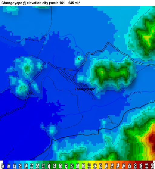
Below is the Elevation map of Chongoyape, which displays elevation range with different colors. Scale of the first map is from 161 to 945 m (528 to 3100 ft) with average elevation of 259.3 meters (=851 ft) [note 1]
These maps also provides idea of topography and contour of this city, they are displayed at different zoom levels. More info about maps, scale and edge coordinates you can find below images.

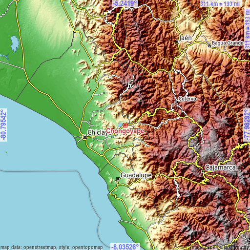
| \ | Map #1 | Map #2 | Topo.Map |
| Scale [m] | 161..945 m | 131..1177 m | × |
| Scale [ft] | 528..3100 ft | 430..3862 ft | × |
| Average | 259.3 m = 851 ft | 326.6 m = 1072 ft | × |
| Width | 9.71 km = 6 mi | 19.41 km = 12.1 mi | 310.6 km = 193 mi |
| Height | 9.71 km = 6 mi | 19.41 km = 12.1 mi | 310.6 km = 193 mi |
| ↑Max Latitude | -6.596908° | -6.553251° | -5.2419° |
| Latitude at center | -6.64056° | -6.64056° | -6.64056° |
| ↓Min Latitude | -6.684209° | -6.727853° | -8.03526° |
| ← Min Longitude | -79.433115° | -79.477061° | -80.79542° |
| Longitude center | -79.38917° | -79.38917° | -79.38917° |
| →Max Longitude | -79.345225° | -79.301279° | -77.98292° |
Nearby cities:
Cities around Chongoyape sort by population:
• Saña elevation 65 m
37.6 km,  214°
214°
• Oyotún 207 m
24.7 km,  156°
156°
• Catache 1343 m
39.5 km,  95°
95°
• La Florida 1041 m
39.1 km,  130°
130°
• Nanchoc 395 m
39 km, 155°
• Manuel Antonio Mesones Muro 63 m
38.5 km,  269°
269°
• Sexi 2474 m
38.3 km,  77°
77°
• Llama 2096 m
32.8 km,  64°
64°
• Licupis 3012 m
29 km,  34°
34°
• Miracosta 2969 m
28.7 km,  23°
23°
• Nueva Arica 174 m
26.3 km,  168°
168°
• Tocmoche 1278 m
25.5 km,  6°
6°
Multilingual:
 En español:
Chongoyape elevación 214 m.
 En France:
Chongoyape élévation 214 m.
 Auf Deutsch:
Chongoyape höhe über dem Meeresspiegel ist 214 m.

Sources and notes:
- [note 1] Map square and city borders are not equal. Map elevation data is calculated only from area inside that square.
- [src 1] Elevation data from geonames database provided with same terms of usage.
- [src 2] The elevation map of Chongoyape is generated using elevation data from NASA's 3 arcsec (90m) resolution SRTM data.
- [src 3] Base (background) map © OpenStreetMap contributors tiles are generated by Geofabrik and OpenTopoMap.
Copyright & License:
This Chongoyape Elevation Map is licensed under CC BY-SA. You may reuse any part from this page, if you give a proper credit by linking to this URL:
 More info on terms of use page.