La Florida elevation
La Florida (Cajamarca, Provincia de San Miguel), Peru elevation is 1041 meters and La Florida elevation in feet is 3415 ft above sea level [src 1]. La Florida is a seat of a third-order administrative division (feature code) with elevation that is 1280 meters (4199 ft) smaller than average city elevation in Peru.
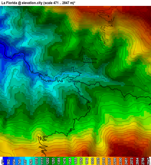
Below is the Elevation map of La Florida, which displays elevation range with different colors. Scale of the first map is from 471 to 2847 m (1545 to 9341 ft) with average elevation of 1499.3 meters (=4919 ft) [note 1]
These maps also provides idea of topography and contour of this city, they are displayed at different zoom levels. More info about maps, scale and edge coordinates you can find below images.
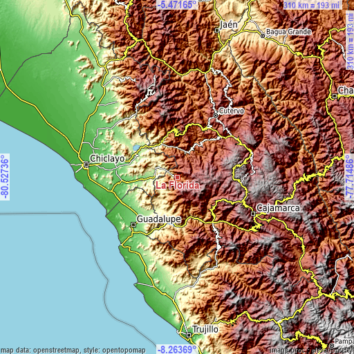
| \ | Map #1 | Topo.Map |
| Scale [m] | 471..2847 m | × |
| Scale [ft] | 1545..9341 ft | × |
| Average | 1499.3 m = 4919 ft | × |
| Width | 9.7 km = 6 mi | 310.4 km = 192.9 mi |
| Height | 9.7 km = 6 mi | 310.5 km = 192.9 mi |
| ↑Max Latitude | -6.826088° | -5.47165° |
| Latitude at center | -6.86972° | -6.86972° |
| ↓Min Latitude | -6.913348° | -8.26369° |
| ← Min Longitude | -79.165055° | -80.52736° |
| Longitude center | -79.12111° | -79.12111° |
| →Max Longitude | -79.077165° | -77.71486° |
Nearby cities:
Cities around La Florida sort by population:
• Chongoyape elevation 214 m
39.1 km,  310°
310°
• Oyotún 207 m
20.1 km,  278°
278°
• San Pablo 2289 m
42 km,  130°
130°
• Llama 2096 m
39.5 km,  0°
0°
• Llapa 3023 m
35.9 km,  110°
110°
• Sexi 2474 m
34.9 km,  12°
12°
• Nueva Arica 174 m
24.5 km,  269°
269°
• Catache 1343 m
23.7 km,  24°
24°
• El Prado 2897 m
22.6 km,  143°
143°
• San Gregorio 1574 m
20.2 km,  173°
173°
• Nanchoc 395 m
16.7 km,  233°
233°
• Niepos 2452 m
6.4 km,  187°
187°
Multilingual:
 En español:
La Florida elevación 1041 m.
 En France:
La Florida élévation 1041 m.
 Auf Deutsch:
La Florida höhe über dem Meeresspiegel ist 1041 m.

Sources and notes:
- [note 1] Map square and city borders are not equal. Map elevation data is calculated only from area inside that square.
- [src 1] Elevation data from geonames database provided with same terms of usage.
- [src 2] The elevation map of La Florida is generated using elevation data from NASA's 3 arcsec (90m) resolution SRTM data.
- [src 3] Base (background) map © OpenStreetMap contributors tiles are generated by Geofabrik and OpenTopoMap.
Copyright & License:
This La Florida Elevation Map is licensed under CC BY-SA. You may reuse any part from this page, if you give a proper credit by linking to this URL:
 More info on terms of use page.