Sexi elevation
Sexi (Cajamarca, Provincia de Santa Cruz), Peru elevation is 2474 meters and Sexi elevation in feet is 8117 ft above sea level [src 1]. Sexi is a seat of a third-order administrative division (feature code) with elevation that is 153 meters (502 ft) bigger than average city elevation in Peru.
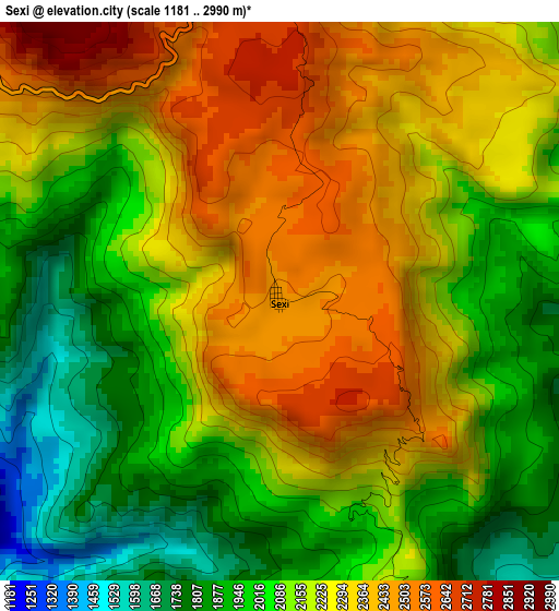
Below is the Elevation map of Sexi, which displays elevation range with different colors. Scale of the first map is from 1181 to 2990 m (3875 to 9810 ft) with average elevation of 2173.7 meters (=7132 ft) [note 1]
These maps also provides idea of topography and contour of this city, they are displayed at different zoom levels. More info about maps, scale and edge coordinates you can find below images.
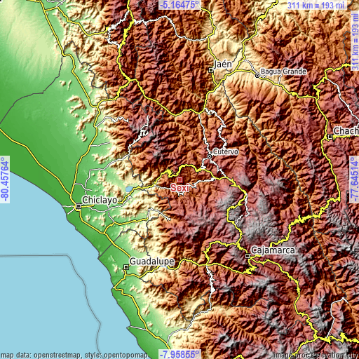
| \ | Map #1 | Topo.Map |
| Scale [m] | 1181..2990 m | × |
| Scale [ft] | 3875..9810 ft | × |
| Average | 2173.7 m = 7132 ft | × |
| Width | 9.71 km = 6 mi | 310.6 km = 193 mi |
| Height | 9.71 km = 6 mi | 310.7 km = 193.1 mi |
| ↑Max Latitude | -6.519951° | -5.16475° |
| Latitude at center | -6.56361° | -6.56361° |
| ↓Min Latitude | -6.607265° | -7.95855° |
| ← Min Longitude | -79.095335° | -80.45764° |
| Longitude center | -79.05139° | -79.05139° |
| →Max Longitude | -79.007445° | -77.64514° |
Nearby cities:
Cities around Sexi sort by population:
• Lajas elevation 2213 m
35.1 km,  90°
90°
• La Florida 1041 m
34.9 km,  192°
192°
• Querocotillo 1966 m
32.2 km,  2°
2°
• Miracosta 2969 m
31.3 km,  304°
304°
• Cutervo 2881 m
31.2 km,  45°
45°
• Uticyacu 1961 m
28.8 km,  105°
105°
• Licupis 3012 m
26.1 km,  306°
306°
• Querocoto 2445 m
22.8 km, 4°
• Cochabamba 1974 m
19 km,  61°
61°
• Huambos 2145 m
14.3 km,  40°
40°
• Catache 1343 m
12.6 km,  170°
170°
• Llama 2096 m
9.4 km, 305°
Multilingual:
 En español:
Sexi elevación 2474 m.
 En France:
Sexi élévation 2474 m.


Sources and notes:
- [note 1] Map square and city borders are not equal. Map elevation data is calculated only from area inside that square.
- [src 1] Elevation data from geonames database provided with same terms of usage.
- [src 2] The elevation map of Sexi is generated using elevation data from NASA's 3 arcsec (90m) resolution SRTM data.
- [src 3] Base (background) map © OpenStreetMap contributors tiles are generated by Geofabrik and OpenTopoMap.
Copyright & License:
This Sexi Elevation Map is licensed under CC BY-SA. You may reuse any part from this page, if you give a proper credit by linking to this URL:
 More info on terms of use page.