Miracosta elevation
Miracosta (Cajamarca, Provincia de Chota), Peru elevation is 2969 meters and Miracosta elevation in feet is 9741 ft above sea level [src 1]. Miracosta is a seat of a third-order administrative division (feature code) with elevation that is 648 meters (2126 ft) bigger than average city elevation in Peru.
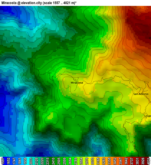
Below is the Elevation map of Miracosta, which displays elevation range with different colors. Scale of the first map is from 1557 to 4021 m (5108 to 13192 ft) with average elevation of 2559.1 meters (=8396 ft) [note 1]
These maps also provides idea of topography and contour of this city, they are displayed at different zoom levels. More info about maps, scale and edge coordinates you can find below images.
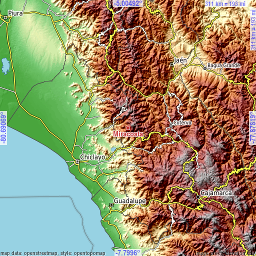
| \ | Map #1 | Topo.Map |
| Scale [m] | 1557..4021 m | × |
| Scale [ft] | 5108..13192 ft | × |
| Average | 2559.1 m = 8396 ft | × |
| Width | 9.71 km = 6 mi | 310.7 km = 193.1 mi |
| Height | 9.71 km = 6 mi | 310.8 km = 193.1 mi |
| ↑Max Latitude | -6.360497° | -5.00492° |
| Latitude at center | -6.40417° | -6.40417° |
| ↓Min Latitude | -6.447839° | -7.7996° |
| ← Min Longitude | -79.328385° | -80.69069° |
| Longitude center | -79.28444° | -79.28444° |
| →Max Longitude | -79.240495° | -77.87819° |
Nearby cities:
Cities around Miracosta sort by population:
• Chongoyape elevation 214 m
28.7 km,  203°
203°
• Catache 1343 m
41 km,  137°
137°
• Cañaris 2411 m
39.9 km,  3°
3°
• Salas 169 m
38.2 km,  292°
292°
• Huambos 2145 m
35.8 km,  101°
101°
• Sexi 2474 m
31.3 km,  124°
124°
• Querocotillo 1966 m
30.8 km,  61°
61°
• Querocoto 2445 m
27.9 km,  79°
79°
• Llama 2096 m
21.9 km, 124°
• Incahuasi 3022 m
19.1 km,  349°
349°
• Tocmoche 1278 m
8.6 km,  263°
263°
• Licupis 3012 m
5.2 km, 115°
Multilingual:
 En español:
Miracosta elevación 2969 m.
 En France:
Miracosta élévation 2969 m.
 Auf Deutsch:
Miracosta höhe über dem Meeresspiegel ist 2969 m.

Sources and notes:
- [note 1] Map square and city borders are not equal. Map elevation data is calculated only from area inside that square.
- [src 1] Elevation data from geonames database provided with same terms of usage.
- [src 2] The elevation map of Miracosta is generated using elevation data from NASA's 3 arcsec (90m) resolution SRTM data.
- [src 3] Base (background) map © OpenStreetMap contributors tiles are generated by Geofabrik and OpenTopoMap.
Copyright & License:
This Miracosta Elevation Map is licensed under CC BY-SA. You may reuse any part from this page, if you give a proper credit by linking to this URL:
 More info on terms of use page.