Llapa elevation
Llapa (Cajamarca, Provincia de San Miguel), Peru elevation is 3023 meters and Llapa elevation in feet is 9918 ft above sea level [src 1]. Llapa is a seat of a third-order administrative division (feature code) with elevation that is 702 meters (2303 ft) bigger than average city elevation in Peru.
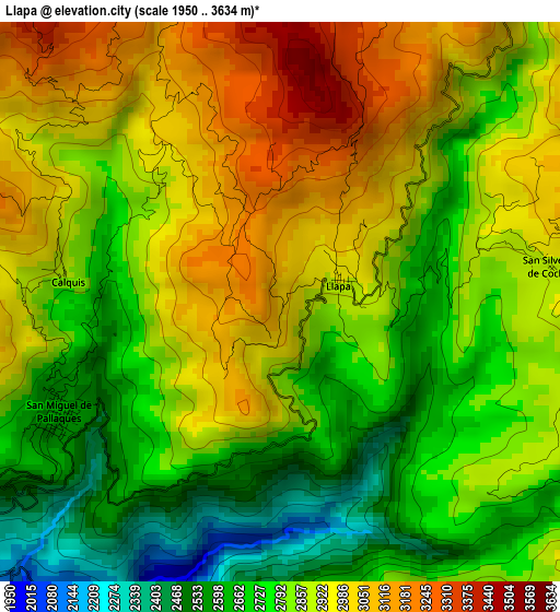
Below is the Elevation map of Llapa, which displays elevation range with different colors. Scale of the first map is from 1950 to 3634 m (6398 to 11923 ft) with average elevation of 2847.4 meters (=9342 ft) [note 1]
These maps also provides idea of topography and contour of this city, they are displayed at different zoom levels. More info about maps, scale and edge coordinates you can find below images.
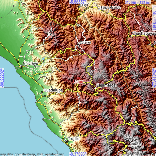
| \ | Map #1 | Topo.Map |
| Scale [m] | 1950..3634 m | × |
| Scale [ft] | 6398..11923 ft | × |
| Average | 2847.4 m = 9342 ft | × |
| Width | 9.7 km = 6 mi | 310.4 km = 192.9 mi |
| Height | 9.7 km = 6 mi | 310.4 km = 192.9 mi |
| ↑Max Latitude | -6.939709° | -5.58557° |
| Latitude at center | -6.98333° | -6.98333° |
| ↓Min Latitude | -7.026947° | -8.37693° |
| ← Min Longitude | -78.860615° | -80.22292° |
| Longitude center | -78.81667° | -78.81667° |
| →Max Longitude | -78.772725° | -77.41042° |
Nearby cities:
Cities around Llapa sort by population:
• Uticyacu elevation 1961 m
39 km,  2°
2°
• Chugur 2434 m
36 km,  11°
11°
• La Florida 1041 m
35.9 km,  290°
290°
• Niepos 2452 m
35 km,  280°
280°
• Magdalena 1249 m
34 km,  150°
150°
• Hualgayoc 3800 m
32.7 km,  42°
42°
• San Gregorio 1574 m
32.1 km,  256°
256°
• Chilete 1137 m
28 km,  187°
187°
• Chetilla 2895 m
24.8 km,  138°
138°
• San Bernardino 1194 m
22.3 km,  184°
184°
• El Prado 2897 m
21 km,  254°
254°
• San Pablo 2289 m
14.9 km, 187°
Multilingual:
 En español:
Llapa elevación 3023 m.
 En France:
Llapa élévation 3023 m.


Sources and notes:
- [note 1] Map square and city borders are not equal. Map elevation data is calculated only from area inside that square.
- [src 1] Elevation data from geonames database provided with same terms of usage.
- [src 2] The elevation map of Llapa is generated using elevation data from NASA's 3 arcsec (90m) resolution SRTM data.
- [src 3] Base (background) map © OpenStreetMap contributors tiles are generated by Geofabrik and OpenTopoMap.
Copyright & License:
This Llapa Elevation Map is licensed under CC BY-SA. You may reuse any part from this page, if you give a proper credit by linking to this URL:
 More info on terms of use page.