Magdalena elevation
Magdalena (Cajamarca, Provincia de Cajamarca), Peru elevation is 1249 meters and Magdalena elevation in feet is 4098 ft above sea level [src 1]. Magdalena is a seat of a third-order administrative division (feature code) with elevation that is 1072 meters (3517 ft) smaller than average city elevation in Peru.
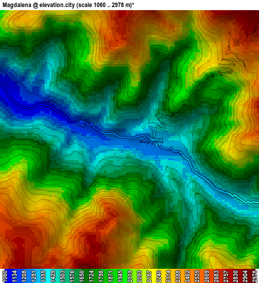
Below is the Elevation map of Magdalena, which displays elevation range with different colors. Scale of the first map is from 1060 to 2978 m (3478 to 9770 ft) with average elevation of 1908.8 meters (=6262 ft) [note 1]
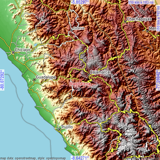
These maps also provides idea of topography and contour of this city, they are displayed at different zoom levels. More info about maps, scale and edge coordinates you can find below images.
| \ | Map #1 | Topo.Map |
| Scale [m] | 1060..2978 m | × |
| Scale [ft] | 3478..9770 ft | × |
| Average | 1908.8 m = 6262 ft | × |
| Width | 9.69 km = 6 mi | 310.2 km = 192.7 mi |
| Height | 9.69 km = 6 mi | 310.2 km = 192.7 mi |
| ↑Max Latitude | -7.206404° | -5.85297° |
| Latitude at center | -7.25° | -7.25° |
| ↓Min Latitude | -7.293592° | -8.64271° |
| ← Min Longitude | -78.710615° | -80.07292° |
| Longitude center | -78.66667° | -78.66667° |
| →Max Longitude | -78.622725° | -77.26042° |
Nearby cities:
Cities around Magdalena sort by population:
• Cajamarca elevation 2684 m
20.7 km,  62°
62°
• Cascas 1236 m
30.8 km,  212°
212°
• Namora 2772 m
37.2 km,  81°
81°
• San Benito 1271 m
35.8 km,  235°
235°
• Llapa 3023 m
34 km,  330°
330°
• Guzmango 2450 m
29.7 km, 240°
• Llacanora 2659 m
26.3 km, 77°
• San Pablo 2289 m
23.6 km,  308°
308°
• Chilete 1137 m
20.3 km,  275°
275°
• San Bernardino 1194 m
19.8 km,  291°
291°
• San Juan 2075 m
19.2 km,  106°
106°
• Chetilla 2895 m
11.1 km,  0°
0°
Multilingual:
 En español:
Magdalena elevación 1249 m.
 En France:
Magdalena élévation 1249 m.
 Auf Deutsch:
Magdalena höhe über dem Meeresspiegel ist 1249 m.

Sources and notes:
- [note 1] Map square and city borders are not equal. Map elevation data is calculated only from area inside that square.
- [src 1] Elevation data from geonames database provided with same terms of usage.
- [src 2] The elevation map of Magdalena is generated using elevation data from NASA's 3 arcsec (90m) resolution SRTM data.
- [src 3] Base (background) map © OpenStreetMap contributors tiles are generated by Geofabrik and OpenTopoMap.
Copyright & License:
This Magdalena Elevation Map is licensed under CC BY-SA. You may reuse any part from this page, if you give a proper credit by linking to this URL:
 More info on terms of use page.