San Bernardino elevation
San Bernardino (Cajamarca, San Pablo), Peru elevation is 1194 meters and San Bernardino elevation in feet is 3917 ft above sea level [src 1]. San Bernardino is a seat of a third-order administrative division (feature code) with elevation that is 1127 meters (3698 ft) smaller than average city elevation in Peru.
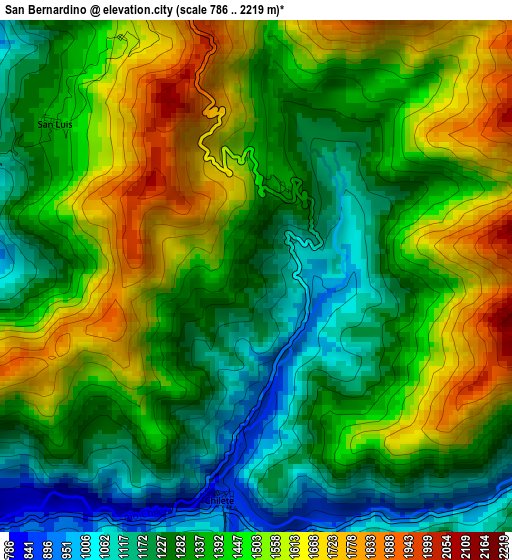
Below is the Elevation map of San Bernardino, which displays elevation range with different colors. Scale of the first map is from 786 to 2219 m (2579 to 7280 ft) with average elevation of 1392 meters (=4567 ft) [note 1]
These maps also provides idea of topography and contour of this city, they are displayed at different zoom levels. More info about maps, scale and edge coordinates you can find below images.
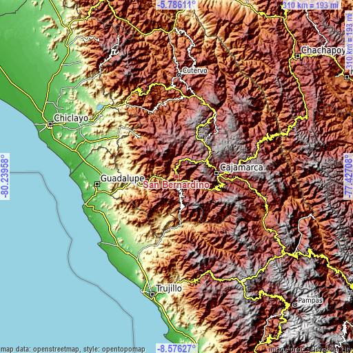
| \ | Map #1 | Topo.Map |
| Scale [m] | 786..2219 m | × |
| Scale [ft] | 2579..7280 ft | × |
| Average | 1392 m = 4567 ft | × |
| Width | 9.7 km = 6 mi | 310.2 km = 192.7 mi |
| Height | 9.7 km = 6 mi | 310.3 km = 192.8 mi |
| ↑Max Latitude | -7.139728° | -5.78611° |
| Latitude at center | -7.18333° | -7.18333° |
| ↓Min Latitude | -7.226928° | -8.57627° |
| ← Min Longitude | -78.877275° | -80.23958° |
| Longitude center | -78.83333° | -78.83333° |
| →Max Longitude | -78.789385° | -77.42708° |
Nearby cities:
Cities around San Bernardino sort by population:
• Cascas elevation 1236 m
33.4 km,  176°
176°
• Tembladera 642 m
36.1 km,  255°
255°
• San Gregorio 1574 m
32.9 km,  296°
296°
• San Benito 1271 m
29.9 km,  201°
201°
• Trinidad 1833 m
28.8 km,  229°
229°
• El Prado 2897 m
24.8 km,  312°
312°
• Guzmango 2450 m
23.4 km, 198°
• Llapa 3023 m
22.3 km,  4°
4°
• Magdalena 1249 m
19.8 km,  111°
111°
• Chetilla 2895 m
18.8 km,  78°
78°
• San Pablo 2289 m
7.4 km, 0°
• Chilete 1137 m
5.9 km, 198°
Multilingual:
 En español:
San Bernardino elevación 1194 m.
 En France:
San Bernardino élévation 1194 m.
 Auf Deutsch:
San Bernardino höhe über dem Meeresspiegel ist 1194 m.

Sources and notes:
- [note 1] Map square and city borders are not equal. Map elevation data is calculated only from area inside that square.
- [src 1] Elevation data from geonames database provided with same terms of usage.
- [src 2] The elevation map of San Bernardino is generated using elevation data from NASA's 3 arcsec (90m) resolution SRTM data.
- [src 3] Base (background) map © OpenStreetMap contributors tiles are generated by Geofabrik and OpenTopoMap.
Copyright & License:
This San Bernardino Elevation Map is licensed under CC BY-SA. You may reuse any part from this page, if you give a proper credit by linking to this URL:
 More info on terms of use page.