San Juan elevation
San Juan (Cajamarca, Provincia de Cajamarca), Peru elevation is 2075 meters and San Juan elevation in feet is 6808 ft above sea level [src 1]. San Juan is a seat of a third-order administrative division (feature code) with elevation that is 246 meters (807 ft) smaller than average city elevation in Peru.
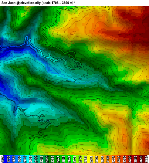
Below is the Elevation map of San Juan, which displays elevation range with different colors. Scale of the first map is from 1706 to 3696 m (5597 to 12126 ft) with average elevation of 2581.7 meters (=8470 ft) [note 1]
These maps also provides idea of topography and contour of this city, they are displayed at different zoom levels. More info about maps, scale and edge coordinates you can find below images.
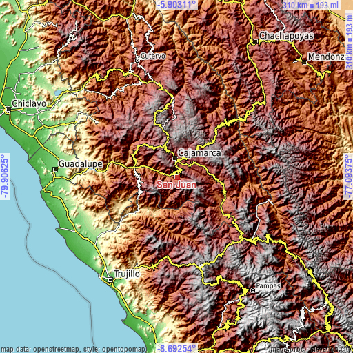
| \ | Map #1 | Topo.Map |
| Scale [m] | 1706..3696 m | × |
| Scale [ft] | 5597..12126 ft | × |
| Average | 2581.7 m = 8470 ft | × |
| Width | 9.69 km = 6 mi | 310.2 km = 192.7 mi |
| Height | 9.69 km = 6 mi | 310.2 km = 192.7 mi |
| ↑Max Latitude | -7.256409° | -5.90311° |
| Latitude at center | -7.3° | -7.3° |
| ↓Min Latitude | -7.343587° | -8.69254° |
| ← Min Longitude | -78.543945° | -79.90625° |
| Longitude center | -78.5° | -78.5° |
| →Max Longitude | -78.456055° | -77.09375° |
Nearby cities:
Cities around San Juan sort by population:
• Cajamarca elevation 2684 m
15.1 km,  359°
359°
• Chilete 1137 m
39.3 km,  280°
280°
• San Bernardino 1194 m
39 km,  289°
289°
• Lucma 2126 m
37.5 km,  188°
188°
• San Marcos 2294 m
35.1 km,  96°
96°
• Sayapullo 2668 m
33.6 km,  173°
173°
• Encañada 3297 m
29.2 km,  34°
34°
• Cachachi 3550 m
29.1 km,  124°
124°
• Chetilla 2895 m
24.8 km,  312°
312°
• Namora 2772 m
21.5 km,  58°
58°
• Magdalena 1249 m
19.2 km, 286°
• Llacanora 2659 m
13.3 km, 33°
Multilingual:
 En español:
San Juan elevación 2075 m.
 En France:
San Juan élévation 2075 m.
 Auf Deutsch:
San Juan höhe über dem Meeresspiegel ist 2075 m.

Sources and notes:
- [note 1] Map square and city borders are not equal. Map elevation data is calculated only from area inside that square.
- [src 1] Elevation data from geonames database provided with same terms of usage.
- [src 2] The elevation map of San Juan is generated using elevation data from NASA's 3 arcsec (90m) resolution SRTM data.
- [src 3] Base (background) map © OpenStreetMap contributors tiles are generated by Geofabrik and OpenTopoMap.
Copyright & License:
This San Juan Elevation Map is licensed under CC BY-SA. You may reuse any part from this page, if you give a proper credit by linking to this URL:
 More info on terms of use page.