San Marcos elevation
San Marcos (Cajamarca), Peru elevation is 2294 meters and San Marcos elevation in feet is 7526 ft above sea level [src 1]. San Marcos is a seat of a third-order administrative division (feature code) with elevation that is 27 meters (89 ft) smaller than average city elevation in Peru.
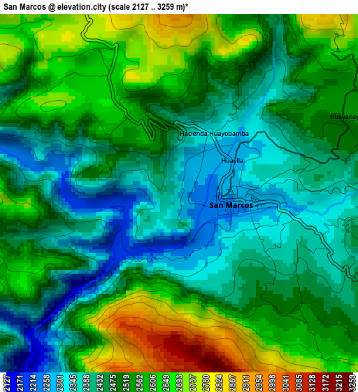
Below is the Elevation map of San Marcos, which displays elevation range with different colors. Scale of the first map is from 2127 to 3259 m (6978 to 10692 ft) with average elevation of 2506.7 meters (=8224 ft) [note 1]
These maps also provides idea of topography and contour of this city, they are displayed at different zoom levels. More info about maps, scale and edge coordinates you can find below images.
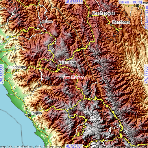
| \ | Map #1 | Topo.Map |
| Scale [m] | 2127..3259 m | × |
| Scale [ft] | 6978..10692 ft | × |
| Average | 2506.7 m = 8224 ft | × |
| Width | 9.69 km = 6 mi | 310.1 km = 192.7 mi |
| Height | 9.69 km = 6 mi | 310.2 km = 192.7 mi |
| ↑Max Latitude | -7.289742° | -5.93653° |
| Latitude at center | -7.33333° | -7.33333° |
| ↓Min Latitude | -7.376914° | -8.72576° |
| ← Min Longitude | -78.227275° | -79.58958° |
| Longitude center | -78.18333° | -78.18333° |
| →Max Longitude | -78.139385° | -76.77708° |
Nearby cities:
Cities around San Marcos sort by population:
• Cajamarca elevation 2684 m
39.7 km,  298°
298°
• Cajabamba 2636 m
34.8 km,  154°
154°
• Oxamarca 2665 m
35.8 km,  21°
21°
• San Juan 2075 m
35.1 km,  276°
276°
• Encañada 3297 m
33.3 km,  326°
326°
• Lluchubamba 3215 m
31.4 km,  131°
131°
• Llacanora 2659 m
31.3 km, 298°
• Cauday 2682 m
29.9 km,  158°
158°
• Namora 2772 m
22.2 km,  311°
311°
• Cachachi 3550 m
17 km,  220°
220°
• La Grama 2057 m
15.8 km, 159°
• Shirac 2724 m
14.8 km,  97°
97°
Multilingual:
 En español:
San Marcos elevación 2294 m.
 En France:
San Marcos élévation 2294 m.
 Auf Deutsch:
San Marcos höhe über dem Meeresspiegel ist 2294 m.

Sources and notes:
- [note 1] Map square and city borders are not equal. Map elevation data is calculated only from area inside that square.
- [src 1] Elevation data from geonames database provided with same terms of usage.
- [src 2] The elevation map of San Marcos is generated using elevation data from NASA's 3 arcsec (90m) resolution SRTM data.
- [src 3] Base (background) map © OpenStreetMap contributors tiles are generated by Geofabrik and OpenTopoMap.
Copyright & License:
This San Marcos Elevation Map is licensed under CC BY-SA. You may reuse any part from this page, if you give a proper credit by linking to this URL:
 More info on terms of use page.