Shirac elevation
Shirac (Cajamarca, San Marcos), Peru elevation is 2724 meters and Shirac elevation in feet is 8937 ft above sea level [src 1]. Shirac is a seat of a third-order administrative division (feature code) with elevation that is 403 meters (1322 ft) bigger than average city elevation in Peru.
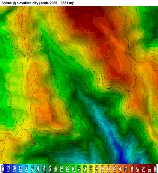
Below is the Elevation map of Shirac, which displays elevation range with different colors. Scale of the first map is from 2065 to 3881 m (6775 to 12733 ft) with average elevation of 3053.6 meters (=10018 ft) [note 1]
These maps also provides idea of topography and contour of this city, they are displayed at different zoom levels. More info about maps, scale and edge coordinates you can find below images.
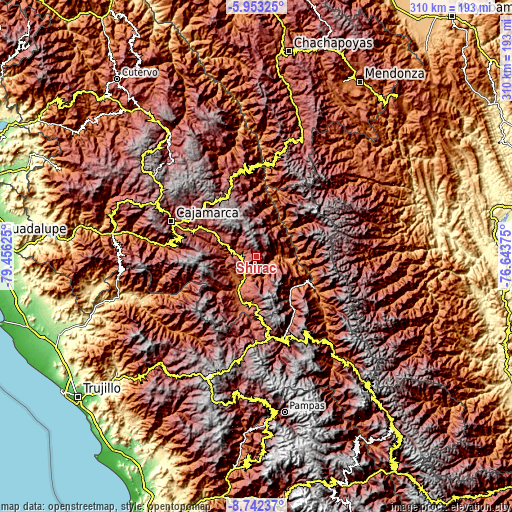
| \ | Map #1 | Topo.Map |
| Scale [m] | 2065..3881 m | × |
| Scale [ft] | 6775..12733 ft | × |
| Average | 3053.6 m = 10018 ft | × |
| Width | 9.69 km = 6 mi | 310.1 km = 192.7 mi |
| Height | 9.69 km = 6 mi | 310.2 km = 192.7 mi |
| ↑Max Latitude | -7.306414° | -5.95325° |
| Latitude at center | -7.35° | -7.35° |
| ↓Min Latitude | -7.393582° | -8.74237° |
| ← Min Longitude | -78.093945° | -79.45625° |
| Longitude center | -78.05° | -78.05° |
| →Max Longitude | -78.006055° | -76.64375° |
Nearby cities:
Cities around Shirac sort by population:
• Cajabamba elevation 2636 m
29.7 km,  180°
180°
• Bolívar 3933 m
44.1 km,  60°
60°
• Marcabal 2797 m
39 km, 177°
• Namora 2772 m
35.4 km,  298°
298°
• Oxamarca 2665 m
35.3 km,  357°
357°
• Longotea 2708 m
34.8 km,  25°
25°
• Ucuncha 1408 m
30.3 km,  37°
37°
• Cachachi 3550 m
28 km,  246°
246°
• Cauday 2682 m
26.2 km,  188°
188°
• Lluchubamba 3215 m
21 km,  155°
155°
• La Grama 2057 m
15.9 km,  215°
215°
• San Marcos 2294 m
14.8 km,  277°
277°
Multilingual:
 En español:
Shirac elevación 2724 m.
 En France:
Shirac élévation 2724 m.


Sources and notes:
- [note 1] Map square and city borders are not equal. Map elevation data is calculated only from area inside that square.
- [src 1] Elevation data from geonames database provided with same terms of usage.
- [src 2] The elevation map of Shirac is generated using elevation data from NASA's 3 arcsec (90m) resolution SRTM data.
- [src 3] Base (background) map © OpenStreetMap contributors tiles are generated by Geofabrik and OpenTopoMap.
Copyright & License:
This Shirac Elevation Map is licensed under CC BY-SA. You may reuse any part from this page, if you give a proper credit by linking to this URL:
 More info on terms of use page.