Ibeto elevation
Ibeto (Niger, Magama), Nigeria elevation is 344 meters and Ibeto elevation in feet is 1129 ft above sea level [src 1]. Ibeto is a populated place (feature code) with elevation that is 47 meters (154 ft) bigger than average city elevation in Nigeria.
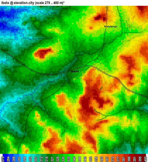
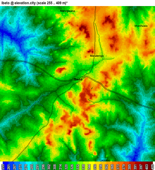
Below is the Elevation map of Ibeto, which displays elevation range with different colors. Scale of the first map is from 279 to 400 m (915 to 1312 ft) with average elevation of 336 meters (=1102 ft) [note 1]
These maps also provides idea of topography and contour of this city, they are displayed at different zoom levels. More info about maps, scale and edge coordinates you can find below images.
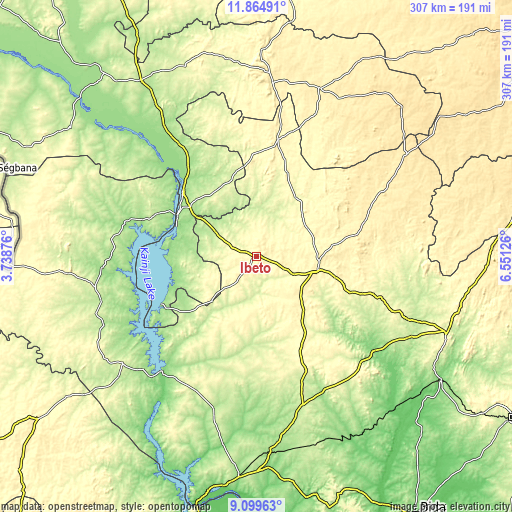
| \ | Map #1 | Map #2 | Topo.Map |
| Scale [m] | 279..400 m | 255..409 m | × |
| Scale [ft] | 915..1312 ft | 837..1342 ft | × |
| Average | 336 m = 1102 ft | 323.8 m = 1062 ft | × |
| Width | 9.61 km = 6 mi | 19.22 km = 11.9 mi | 307.5 km = 191.1 mi |
| Height | 9.61 km = 6 mi | 19.22 km = 11.9 mi | 307.5 km = 191.1 mi |
| ↑Max Latitude | 10.528568° | 10.571771° | 11.86491° |
| Latitude at center | 10.48536° | 10.48536° | 10.48536° |
| ↓Min Latitude | 10.442145° | 10.398925° | 9.09963° |
| ← Min Longitude | 5.101065° | 5.057119° | 3.73876° |
| Longitude center | 5.14501° | 5.14501° | 5.14501° |
| →Max Longitude | 5.188955° | 5.232901° | 6.55126° |
Nearby cities:
Cities around Ibeto sort by population:
• Kontagora elevation 339 m
36.8 km,  104°
104°
• Rijau 358 m
69.8 km,  9°
9°
• Bin Yauri 204 m
49.2 km,  312°
312°
• Auna 198 m
56.8 km,  234°
234°
• New Shagunnu 153 m
75.7 km,  257°
257°
• Ukata 420 m
83.7 km,  62°
62°
• Bangi 427 m
84 km, 62°
• Sakaba 356 m
81.1 km,  37°
37°
• Agwara 208 m
66.3 km,  291°
291°
• Wara 151 m
63.8 km,  243°
243°
• Yelwa 155 m
58.7 km, 311°
• Nasko 269 m
26.9 km,  272°
272°
Multilingual:
 En español:
Ibeto elevación 344 m.
 En France:
Ibeto élévation 344 m.


Sources and notes:
- [note 1] Map square and city borders are not equal. Map elevation data is calculated only from area inside that square.
- [src 1] Elevation data from geonames database provided with same terms of usage.
- [src 2] The elevation map of Ibeto is generated using elevation data from NASA's 3 arcsec (90m) resolution SRTM data.
- [src 3] Base (background) map © OpenStreetMap contributors tiles are generated by Geofabrik and OpenTopoMap.
Copyright & License:
This Ibeto Elevation Map is licensed under CC BY-SA. You may reuse any part from this page, if you give a proper credit by linking to this URL:
 More info on terms of use page.