Rijau elevation
Rijau (Niger), Nigeria elevation is 358 meters and Rijau elevation in feet is 1175 ft above sea level [src 1]. Rijau is a seat of a second-order administrative division (feature code) with elevation that is 61 meters (200 ft) bigger than average city elevation in Nigeria.
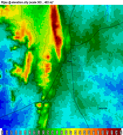
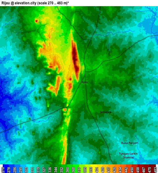
Below is the Elevation map of Rijau, which displays elevation range with different colors. Scale of the first map is from 303 to 483 m (994 to 1585 ft) with average elevation of 357.8 meters (=1174 ft) [note 1]
These maps also provides idea of topography and contour of this city, they are displayed at different zoom levels. More info about maps, scale and edge coordinates you can find below images.
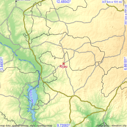
| \ | Map #1 | Map #2 | Topo.Map |
| Scale [m] | 303..483 m | 270..483 m | × |
| Scale [ft] | 994..1585 ft | 886..1585 ft | × |
| Average | 357.8 m = 1174 ft | 334.1 m = 1096 ft | × |
| Width | 9.59 km = 6 mi | 19.18 km = 11.9 mi | 306.8 km = 190.6 mi |
| Height | 9.59 km = 6 mi | 19.18 km = 11.9 mi | 306.9 km = 190.7 mi |
| ↑Max Latitude | 11.147009° | 11.190123° | 12.48043° |
| Latitude at center | 11.10389° | 11.10389° | 11.10389° |
| ↓Min Latitude | 11.060764° | 11.017632° | 9.72083° |
| ← Min Longitude | 5.211615° | 5.167669° | 3.84931° |
| Longitude center | 5.25556° | 5.25556° | 5.25556° |
| →Max Longitude | 5.299505° | 5.343451° | 6.66181° |
Nearby cities:
Cities around Rijau sort by population:
• Zuru elevation 394 m
36.9 km,  356°
356°
• Ibeto 344 m
69.8 km,  189°
189°
• Bin Yauri 204 m
60.3 km,  233°
233°
• Mahuta 271 m
58.2 km,  329°
329°
• Wasagu 501 m
66.2 km,  62°
62°
• Duku 279 m
40.7 km,  291°
291°
• Ukata 420 m
69.2 km,  116°
116°
• Dabai 452 m
41.8 km,  352°
352°
• Bangi 427 m
69.2 km, 115°
• Yelwa 155 m
63.5 km,  241°
241°
• Ribah 388 m
41.1 km,  37°
37°
• Sakaba 356 m
37.4 km,  96°
96°
Multilingual:
 En español:
Rijau elevación 358 m.
 En France:
Rijau élévation 358 m.


Sources and notes:
- [note 1] Map square and city borders are not equal. Map elevation data is calculated only from area inside that square.
- [src 1] Elevation data from geonames database provided with same terms of usage.
- [src 2] The elevation map of Rijau is generated using elevation data from NASA's 3 arcsec (90m) resolution SRTM data.
- [src 3] Base (background) map © OpenStreetMap contributors tiles are generated by Geofabrik and OpenTopoMap.
Copyright & License:
This Rijau Elevation Map is licensed under CC BY-SA. You may reuse any part from this page, if you give a proper credit by linking to this URL:
 More info on terms of use page.