Kontagora elevation
Kontagora (Niger), Nigeria elevation is 339 meters and Kontagora elevation in feet is 1112 ft above sea level [src 1]. Kontagora is a seat of a second-order administrative division (feature code) with elevation that is 42 meters (138 ft) bigger than average city elevation in Nigeria.
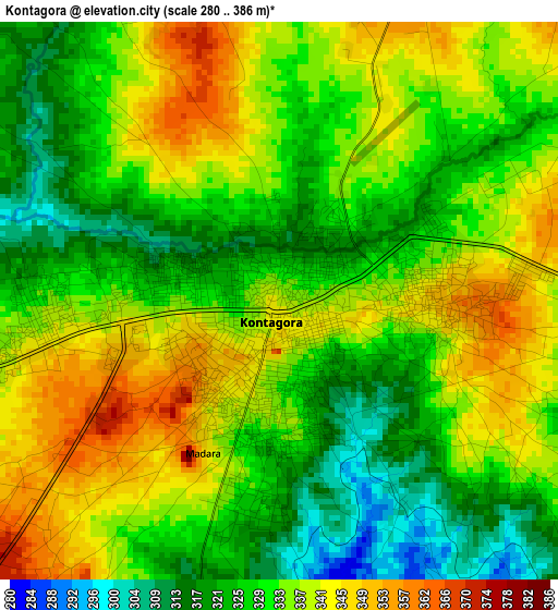
Below is the Elevation map of Kontagora, which displays elevation range with different colors. Scale of the first map is from 280 to 386 m (919 to 1266 ft) with average elevation of 332.7 meters (=1092 ft) [note 1]
These maps also provides idea of topography and contour of this city, they are displayed at different zoom levels. More info about maps, scale and edge coordinates you can find below images.
| \ | Map #1 | Map #2 | Topo.Map |
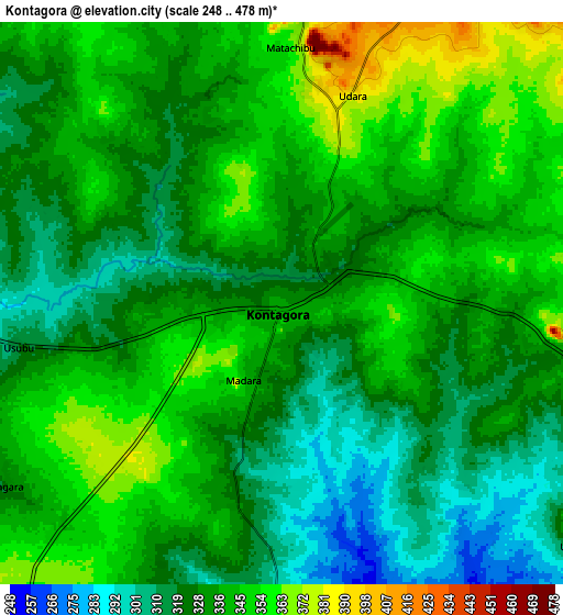
| Scale [m] | 280..386 m | 248..478 m | × |
| Scale [ft] | 919..1266 ft | 814..1568 ft | × |
| Average | 332.7 m = 1092 ft | 333.4 m = 1094 ft | × |
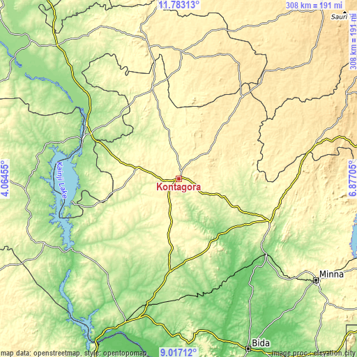
| Width | 9.61 km = 6 mi | 19.22 km = 11.9 mi | 307.6 km = 191.1 mi |
| Height | 9.61 km = 6 mi | 19.22 km = 11.9 mi | 307.6 km = 191.1 mi |
| ↑Max Latitude | 10.44641° | 10.489624° | 11.78313° |
| Latitude at center | 10.40319° | 10.40319° | 10.40319° |
| ↓Min Latitude | 10.359964° | 10.316732° | 9.01712° |
| ← Min Longitude | 5.426855° | 5.382909° | 4.06455° |
| Longitude center | 5.4708° | 5.4708° | 5.4708° |
| →Max Longitude | 5.514745° | 5.558691° | 6.87705° |
Nearby cities:
Cities around Kontagora sort by population:
• Tegina elevation 270 m
87 km,  115°
115°
• Rijau 358 m
81.4 km,  343°
343°
• Ibeto 344 m
36.8 km,  284°
284°
• Bin Yauri 204 m
83.5 km,  300°
300°
• Auna 198 m
85.2 km,  253°
253°
• Ukata 420 m
61.3 km,  39°
39°
• Yelwa 155 m
93 km, 301°
• Kagara 287 m
89.1 km,  105°
105°
• Sakaba 356 m
74.9 km,  10°
10°
• Nasko 269 m
63.4 km, 279°
• Bangi 427 m
61.7 km, 39°
• Mashegu 151 m
58.6 km,  144°
144°
Multilingual:
 En español:
Kontagora elevación 339 m.
 En France:
Kontagora élévation 339 m.
 Auf Deutsch:
Kontagora höhe über dem Meeresspiegel ist 339 m.

Sources and notes:
- [note 1] Map square and city borders are not equal. Map elevation data is calculated only from area inside that square.
- [src 1] Elevation data from geonames database provided with same terms of usage.
- [src 2] The elevation map of Kontagora is generated using elevation data from NASA's 3 arcsec (90m) resolution SRTM data.
- [src 3] Base (background) map © OpenStreetMap contributors tiles are generated by Geofabrik and OpenTopoMap.
Copyright & License:
This Kontagora Elevation Map is licensed under CC BY-SA. You may reuse any part from this page, if you give a proper credit by linking to this URL:
 More info on terms of use page.