Auna elevation
Auna (Niger, Magama), Nigeria elevation is 198 meters and Auna elevation in feet is 650 ft above sea level [src 1]. Auna is a populated place (feature code) with elevation that is 99 meters (325 ft) smaller than average city elevation in Nigeria.
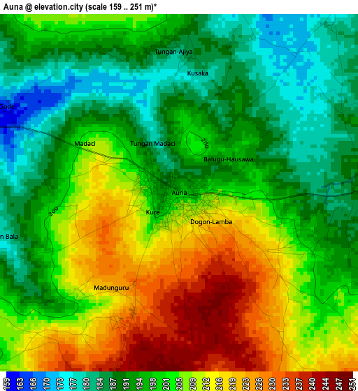
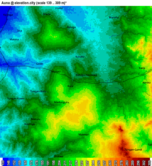
Below is the Elevation map of Auna, which displays elevation range with different colors. Scale of the first map is from 159 to 251 m (522 to 823 ft) with average elevation of 201.1 meters (=660 ft) [note 1]
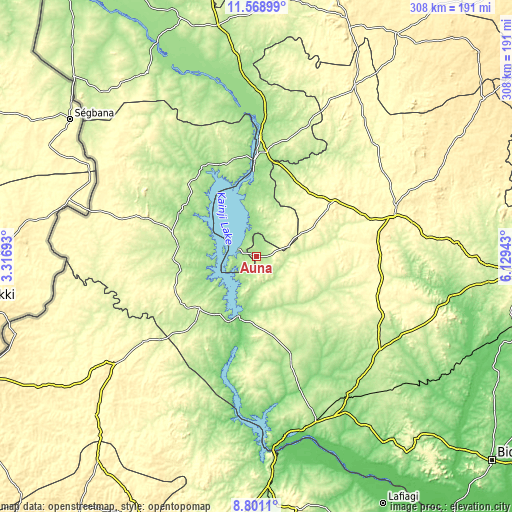
These maps also provides idea of topography and contour of this city, they are displayed at different zoom levels. More info about maps, scale and edge coordinates you can find below images.
| \ | Map #1 | Map #2 | Topo.Map |
| Scale [m] | 159..251 m | 139..309 m | × |
| Scale [ft] | 522..823 ft | 456..1014 ft | × |
| Average | 201.1 m = 660 ft | 199.1 m = 653 ft | × |
| Width | 9.62 km = 6 mi | 19.24 km = 12 mi | 307.8 km = 191.3 mi |
| Height | 9.62 km = 6 mi | 19.24 km = 12 mi | 307.8 km = 191.3 mi |
| ↑Max Latitude | 10.231299° | 10.274543° | 11.56899° |
| Latitude at center | 10.18805° | 10.18805° | 10.18805° |
| ↓Min Latitude | 10.144795° | 10.101533° | 8.8011° |
| ← Min Longitude | 4.679235° | 4.635289° | 3.31693° |
| Longitude center | 4.72318° | 4.72318° | 4.72318° |
| →Max Longitude | 4.767125° | 4.811071° | 6.12943° |
Nearby cities:
Cities around Auna sort by population:
• Kontagora elevation 339 m
85.2 km,  73°
73°
• Ibeto 344 m
56.8 km,  54°
54°
• Bin Yauri 204 m
66.8 km,  8°
8°
• Wawa 254 m
46 km,  226°
226°
• Bokani 169 m
98.8 km,  148°
148°
• Konkwesso 265 m
100.2 km,  317°
317°
• New Shagunnu 153 m
32.5 km,  301°
301°
• Yelwa 155 m
72 km,  1°
1°
• Agwara 208 m
59.7 km,  344°
344°
• New Bussa 201 m
41 km,  215°
215°
• Nasko 269 m
39.2 km,  29°
29°
• Wara 151 m
11.8 km,  292°
292°
Multilingual:
 En español:
Auna elevación 198 m.
 En France:
Auna élévation 198 m.


Sources and notes:
- [note 1] Map square and city borders are not equal. Map elevation data is calculated only from area inside that square.
- [src 1] Elevation data from geonames database provided with same terms of usage.
- [src 2] The elevation map of Auna is generated using elevation data from NASA's 3 arcsec (90m) resolution SRTM data.
- [src 3] Base (background) map © OpenStreetMap contributors tiles are generated by Geofabrik and OpenTopoMap.
Copyright & License:
This Auna Elevation Map is licensed under CC BY-SA. You may reuse any part from this page, if you give a proper credit by linking to this URL:
 More info on terms of use page.