Bokani elevation
Bokani (Niger, Mokwa), Nigeria elevation is 169 meters and Bokani elevation in feet is 554 ft above sea level [src 1]. Bokani is a populated place (feature code) with elevation that is 128 meters (420 ft) smaller than average city elevation in Nigeria.
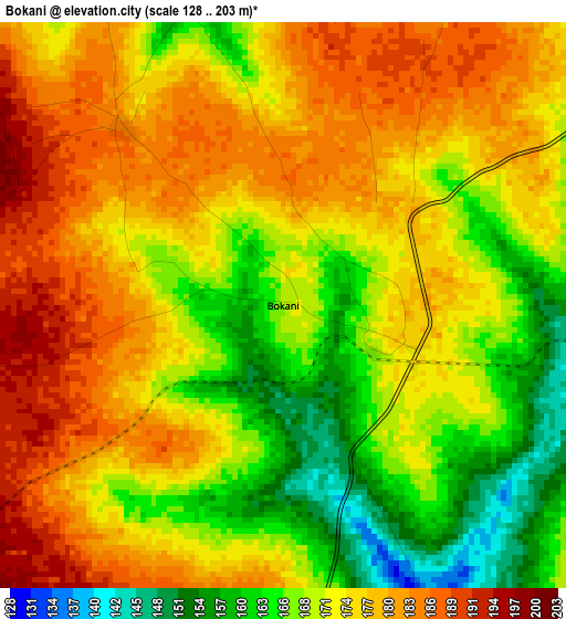
Below is the Elevation map of Bokani, which displays elevation range with different colors. Scale of the first map is from 128 to 203 m (420 to 666 ft) with average elevation of 173.3 meters (=569 ft) [note 1]
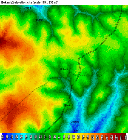
These maps also provides idea of topography and contour of this city, they are displayed at different zoom levels. More info about maps, scale and edge coordinates you can find below images.
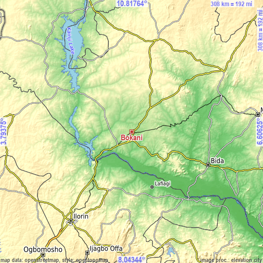
| \ | Map #1 | Map #2 | Topo.Map |
| Scale [m] | 128..203 m | 115..236 m | × |
| Scale [ft] | 420..666 ft | 377..774 ft | × |
| Average | 173.3 m = 569 ft | 172.5 m = 566 ft | × |
| Width | 9.64 km = 6 mi | 19.28 km = 12 mi | 308.5 km = 191.7 mi |
| Height | 9.64 km = 6 mi | 19.28 km = 12 mi | 308.5 km = 191.7 mi |
| ↑Max Latitude | 9.476678° | 9.520021° | 10.81764° |
| Latitude at center | 9.43333° | 9.43333° | 9.43333° |
| ↓Min Latitude | 9.389976° | 9.346617° | 8.04344° |
| ← Min Longitude | 5.156055° | 5.112109° | 3.79375° |
| Longitude center | 5.2° | 5.2° | 5.2° |
| →Max Longitude | 5.243945° | 5.287891° | 6.60625° |
Nearby cities:
Cities around Bokani sort by population:
• Bida elevation 118 m
97.2 km,  113°
113°
• Lafiagi 116 m
68.8 km,  159°
159°
• Jebba 56 m
54.1 km,  229°
229°
• Mokwa 153 m
22.2 km, 226°
• Bode Saadu 151 m
71.6 km,  219°
219°
• Auna 198 m
98.8 km,  328°
328°
• New Bussa 201 m
91 km,  303°
303°
• Lemu 139 m
90.9 km,  92°
92°
• Mashegu 151 m
87.3 km,  46°
46°
• Share 295 m
72.5 km,  200°
200°
• Enagi 174 m
50.8 km,  132°
132°
• Kutigi 204 m
50.5 km,  120°
120°
Multilingual:
 En español:
Bokani elevación 169 m.
 En France:
Bokani élévation 169 m.


Sources and notes:
- [note 1] Map square and city borders are not equal. Map elevation data is calculated only from area inside that square.
- [src 1] Elevation data from geonames database provided with same terms of usage.
- [src 2] The elevation map of Bokani is generated using elevation data from NASA's 3 arcsec (90m) resolution SRTM data.
- [src 3] Base (background) map © OpenStreetMap contributors tiles are generated by Geofabrik and OpenTopoMap.
Copyright & License:
This Bokani Elevation Map is licensed under CC BY-SA. You may reuse any part from this page, if you give a proper credit by linking to this URL:
 More info on terms of use page.