Bode Saadu elevation
Bode Saadu (Kwara, Moro), Nigeria elevation is 151 meters and Bode Saadu elevation in feet is 495 ft above sea level [src 1]. Bode Saadu is a seat of a second-order administrative division (feature code) with elevation that is 146 meters (479 ft) smaller than average city elevation in Nigeria.
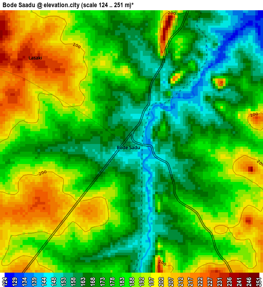
Below is the Elevation map of Bode Saadu, which displays elevation range with different colors. Scale of the first map is from 124 to 251 m (407 to 823 ft) with average elevation of 181.1 meters (=594 ft) [note 1]
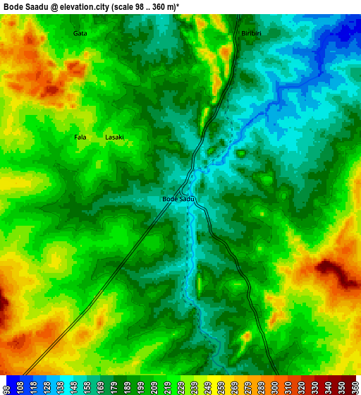
These maps also provides idea of topography and contour of this city, they are displayed at different zoom levels. More info about maps, scale and edge coordinates you can find below images.
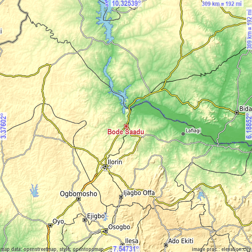
| \ | Map #1 | Map #2 | Topo.Map |
| Scale [m] | 124..251 m | 98..360 m | × |
| Scale [ft] | 407..823 ft | 322..1181 ft | × |
| Average | 181.1 m = 594 ft | 205 m = 673 ft | × |
| Width | 9.65 km = 6 mi | 19.31 km = 12 mi | 308.9 km = 191.9 mi |
| Height | 9.65 km = 6 mi | 19.31 km = 12 mi | 308.9 km = 191.9 mi |
| ↑Max Latitude | 8.982409° | 9.025813° | 10.32539° |
| Latitude at center | 8.939° | 8.939° | 8.939° |
| ↓Min Latitude | 8.895586° | 8.852167° | 7.54731° |
| ← Min Longitude | 4.738325° | 4.694379° | 3.37602° |
| Longitude center | 4.78227° | 4.78227° | 4.78227° |
| →Max Longitude | 4.826215° | 4.870161° | 6.18852° |
Nearby cities:
Cities around Bode Saadu sort by population:
• Ilorin elevation 320 m
55.8 km,  208°
208°
• Lafiagi 116 m
70.3 km,  97°
97°
• Igbeti 371 m
74.6 km,  253°
253°
• Jebba 56 m
20.6 km,  12°
12°
• Mokwa 153 m
49.6 km,  37°
37°
• Alapa 357 m
56.6 km,  230°
230°
• Bokani 169 m
71.6 km, 39°
• Owu-Isin 434 m
77.7 km,  160°
160°
• Afon 336 m
75 km,  201°
201°
• Fufu 401 m
55 km,  187°
187°
• Oke-Oyi 378 m
40.3 km, 190°
• Share 295 m
24.8 km,  122°
122°
Multilingual:
 En español:
Bode Saadu elevación 151 m.
 En France:
Bode Saadu élévation 151 m.
 Auf Deutsch:
Bode Saadu höhe über dem Meeresspiegel ist 151 m.

Sources and notes:
- [note 1] Map square and city borders are not equal. Map elevation data is calculated only from area inside that square.
- [src 1] Elevation data from geonames database provided with same terms of usage.
- [src 2] The elevation map of Bode Saadu is generated using elevation data from NASA's 3 arcsec (90m) resolution SRTM data.
- [src 3] Base (background) map © OpenStreetMap contributors tiles are generated by Geofabrik and OpenTopoMap.
Copyright & License:
This Bode Saadu Elevation Map is licensed under CC BY-SA. You may reuse any part from this page, if you give a proper credit by linking to this URL:
 More info on terms of use page.