Owu-Isin elevation
Owu-Isin (Kwara, Isin), Nigeria elevation is 434 meters and Owu-Isin elevation in feet is 1424 ft above sea level [src 1]. Owu-Isin is a seat of a second-order administrative division (feature code) with elevation that is 137 meters (449 ft) bigger than average city elevation in Nigeria.
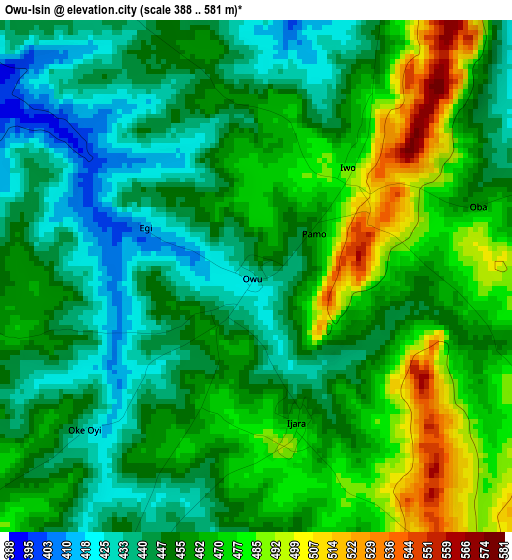
Below is the Elevation map of Owu-Isin, which displays elevation range with different colors. Scale of the first map is from 388 to 581 m (1273 to 1906 ft) with average elevation of 457.9 meters (=1502 ft) [note 1]
These maps also provides idea of topography and contour of this city, they are displayed at different zoom levels. More info about maps, scale and edge coordinates you can find below images.
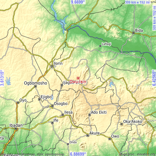
| \ | Map #1 | Topo.Map |
| Scale [m] | 388..581 m | × |
| Scale [ft] | 1273..1906 ft | × |
| Average | 457.9 m = 1502 ft | × |
| Width | 9.67 km = 6 mi | 309.4 km = 192.3 mi |
| Height | 9.67 km = 6 mi | 309.5 km = 192.3 mi |
| ↑Max Latitude | 8.324385° | 9.6699° |
| Latitude at center | 8.2809° | 8.2809° |
| ↓Min Latitude | 8.23741° | 6.88699° |
| ← Min Longitude | 4.975455° | 3.61315° |
| Longitude center | 5.0194° | 5.0194° |
| →Max Longitude | 5.063345° | 6.42565° |
Nearby cities:
Cities around Owu-Isin sort by population:
• Ila Orangun elevation 493 m
32 km,  203°
203°
• Offa 419 m
36 km,  245°
245°
• Oyan 422 m
37.9 km,  227°
227°
• Oke Ila 540 m
37 km,  186°
186°
• Omu-Aran 556 m
18.3 km,  149°
149°
• Ajasse Ipo 402 m
22.9 km,  256°
256°
• Ilemona 411 m
43.8 km,  244°
244°
• Iye-Ekiti 564 m
43.2 km, 147°
• Fufu 401 m
37.8 km,  299°
299°
• Araromi-Opin 521 m
35.2 km,  132°
132°
• Otun-Ekiti 535 m
34.4 km,  160°
160°
• Iloffa 568 m
24.9 km, 147°
Multilingual:
 En español:
Owu-Isin elevación 434 m.
 En France:
Owu-Isin élévation 434 m.
 Auf Deutsch:
Owu-Isin höhe über dem Meeresspiegel ist 434 m.

Sources and notes:
- [note 1] Map square and city borders are not equal. Map elevation data is calculated only from area inside that square.
- [src 1] Elevation data from geonames database provided with same terms of usage.
- [src 2] The elevation map of Owu-Isin is generated using elevation data from NASA's 3 arcsec (90m) resolution SRTM data.
- [src 3] Base (background) map © OpenStreetMap contributors tiles are generated by Geofabrik and OpenTopoMap.
Copyright & License:
This Owu-Isin Elevation Map is licensed under CC BY-SA. You may reuse any part from this page, if you give a proper credit by linking to this URL:
 More info on terms of use page.