Alapa elevation
Alapa (Oyo), Nigeria elevation is 357 meters and Alapa elevation in feet is 1171 ft above sea level [src 1]. Alapa is a populated place (feature code) with elevation that is 60 meters (197 ft) bigger than average city elevation in Nigeria.
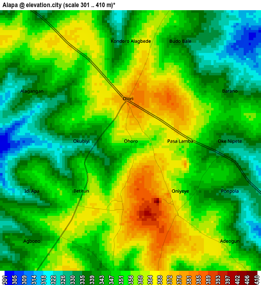
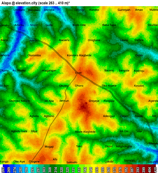
Below is the Elevation map of Alapa, which displays elevation range with different colors. Scale of the first map is from 301 to 410 m (988 to 1345 ft) with average elevation of 349.3 meters (=1146 ft) [note 1]
These maps also provides idea of topography and contour of this city, they are displayed at different zoom levels. More info about maps, scale and edge coordinates you can find below images.
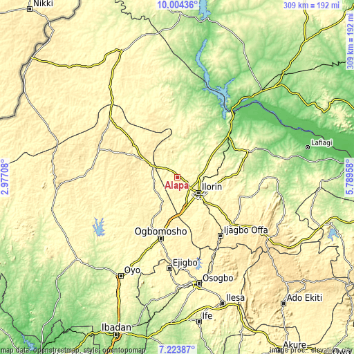
| \ | Map #1 | Map #2 | Topo.Map |
| Scale [m] | 301..410 m | 263..410 m | × |
| Scale [ft] | 988..1345 ft | 863..1345 ft | × |
| Average | 349.3 m = 1146 ft | 332.6 m = 1091 ft | × |
| Width | 9.66 km = 6 mi | 19.32 km = 12 mi | 309.2 km = 192.1 mi |
| Height | 9.66 km = 6 mi | 19.32 km = 12 mi | 309.2 km = 192.1 mi |
| ↑Max Latitude | 8.660117° | 8.703559° | 10.00436° |
| Latitude at center | 8.61667° | 8.61667° | 8.61667° |
| ↓Min Latitude | 8.573218° | 8.529761° | 7.22387° |
| ← Min Longitude | 4.339385° | 4.295439° | 2.97708° |
| Longitude center | 4.38333° | 4.38333° | 4.38333° |
| →Max Longitude | 4.427275° | 4.471221° | 5.78958° |
Nearby cities:
Cities around Alapa sort by population:
• Ilorin elevation 320 m
22 km,  127°
127°
• Offa 419 m
63.9 km,  144°
144°
• Igbeti 371 m
31.4 km,  297°
297°
• Bode Saadu 151 m
56.6 km,  50°
50°
• Ajasse Ipo 402 m
63.9 km, 131°
• Ilemona 411 m
64.1 km,  151°
151°
• Iresa-Adu 387 m
58.9 km,  179°
179°
• Ogbomoso 361 m
56 km,  196°
196°
• Ikoyi-Ile 380 m
47.5 km,  209°
209°
• Fufu 401 m
41.6 km,  116°
116°
• Afon 336 m
37.3 km, 154°
• Oke-Oyi 378 m
36.8 km,  95°
95°
Multilingual:
 En español:
Alapa elevación 357 m.
 En France:
Alapa élévation 357 m.


Sources and notes:
- [note 1] Map square and city borders are not equal. Map elevation data is calculated only from area inside that square.
- [src 1] Elevation data from geonames database provided with same terms of usage.
- [src 2] The elevation map of Alapa is generated using elevation data from NASA's 3 arcsec (90m) resolution SRTM data.
- [src 3] Base (background) map © OpenStreetMap contributors tiles are generated by Geofabrik and OpenTopoMap.
Copyright & License:
This Alapa Elevation Map is licensed under CC BY-SA. You may reuse any part from this page, if you give a proper credit by linking to this URL:
 More info on terms of use page.