Ikoyi-Ile elevation
Ikoyi-Ile (Oyo, Ori Ire), Nigeria elevation is 380 meters and Ikoyi-Ile elevation in feet is 1247 ft above sea level [src 1]. Ikoyi-Ile is a seat of a second-order administrative division (feature code) with elevation that is 83 meters (272 ft) bigger than average city elevation in Nigeria.
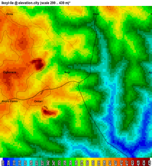
Below is the Elevation map of Ikoyi-Ile, which displays elevation range with different colors. Scale of the first map is from 299 to 439 m (981 to 1440 ft) with average elevation of 362.7 meters (=1190 ft) [note 1]
These maps also provides idea of topography and contour of this city, they are displayed at different zoom levels. More info about maps, scale and edge coordinates you can find below images.
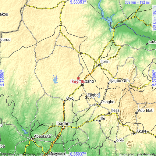
| \ | Map #1 | Topo.Map |
| Scale [m] | 299..439 m | × |
| Scale [ft] | 981..1440 ft | × |
| Average | 362.7 m = 1190 ft | × |
| Width | 9.67 km = 6 mi | 309.5 km = 192.3 mi |
| Height | 9.67 km = 6 mi | 309.5 km = 192.3 mi |
| ↑Max Latitude | 8.287889° | 9.63353° |
| Latitude at center | 8.2444° | 8.2444° |
| ↓Min Latitude | 8.200906° | 6.85037° |
| ← Min Longitude | 4.127865° | 2.76556° |
| Longitude center | 4.17181° | 4.17181° |
| →Max Longitude | 4.215755° | 5.57806° |
Nearby cities:
Cities around Ikoyi-Ile sort by population:
• Ilorin elevation 320 m
49.5 km,  55°
55°
• Oyo 298 m
51 km,  211°
211°
• Inisa 368 m
47.3 km,  157°
157°
• Ejigbo 353 m
41.1 km, 157°
• Alapa 357 m
47.5 km,  29°
29°
• Ilemona 411 m
55.8 km,  105°
105°
• Bode Osi 298 m
55.2 km,  173°
173°
• Ifon 352 m
54.3 km,  141°
141°
• Afon 336 m
39.9 km,  78°
78°
• Ajaawa 292 m
35.2 km,  188°
188°
• Iresa-Adu 387 m
29.9 km,  125°
125°
• Ogbomoso 361 m
14.4 km,  148°
148°
Multilingual:
 En español:
Ikoyi-Ile elevación 380 m.
 En France:
Ikoyi-Ile élévation 380 m.
 Auf Deutsch:
Ikoyi-Ile höhe über dem Meeresspiegel ist 380 m.

Sources and notes:
- [note 1] Map square and city borders are not equal. Map elevation data is calculated only from area inside that square.
- [src 1] Elevation data from geonames database provided with same terms of usage.
- [src 2] The elevation map of Ikoyi-Ile is generated using elevation data from NASA's 3 arcsec (90m) resolution SRTM data.
- [src 3] Base (background) map © OpenStreetMap contributors tiles are generated by Geofabrik and OpenTopoMap.
Copyright & License:
This Ikoyi-Ile Elevation Map is licensed under CC BY-SA. You may reuse any part from this page, if you give a proper credit by linking to this URL:
 More info on terms of use page.