Bida elevation
Bida (Niger), Nigeria elevation is 118 meters and Bida elevation in feet is 387 ft above sea level [src 1]. Bida is a seat of a second-order administrative division (feature code) with elevation that is 179 meters (587 ft) smaller than average city elevation in Nigeria.
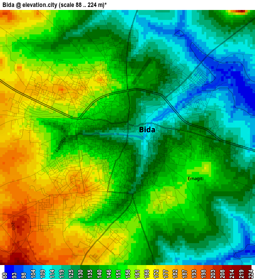
Below is the Elevation map of Bida, which displays elevation range with different colors. Scale of the first map is from 88 to 224 m (289 to 735 ft) with average elevation of 144.6 meters (=474 ft) [note 1]
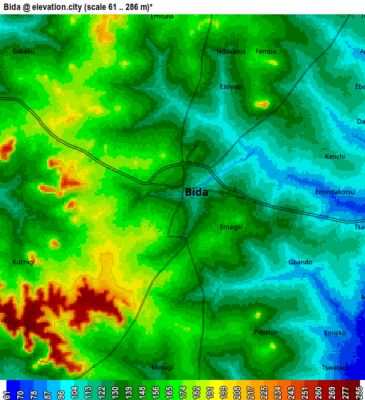
These maps also provides idea of topography and contour of this city, they are displayed at different zoom levels. More info about maps, scale and edge coordinates you can find below images.
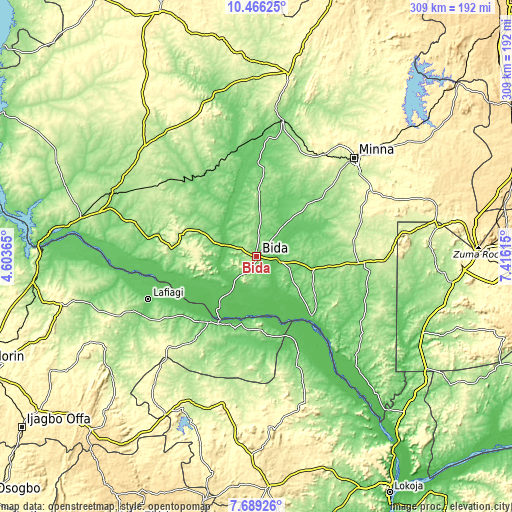
| \ | Map #1 | Map #2 | Topo.Map |
| Scale [m] | 88..224 m | 61..286 m | × |
| Scale [ft] | 289..735 ft | 200..938 ft | × |
| Average | 144.6 m = 474 ft | 144.9 m = 475 ft | × |
| Width | 9.65 km = 6 mi | 19.3 km = 12 mi | 308.8 km = 191.9 mi |
| Height | 9.65 km = 6 mi | 19.3 km = 12 mi | 308.8 km = 191.9 mi |
| ↑Max Latitude | 9.123832° | 9.167219° | 10.46625° |
| Latitude at center | 9.08044° | 9.08044° | 9.08044° |
| ↓Min Latitude | 9.037043° | 8.99364° | 7.68926° |
| ← Min Longitude | 5.965955° | 5.922009° | 4.60365° |
| Longitude center | 6.0099° | 6.0099° | 6.0099° |
| →Max Longitude | 6.053845° | 6.097791° | 7.41615° |
Nearby cities:
Cities around Bida sort by population:
• Lafiagi elevation 116 m
69.9 km,  248°
248°
• Patigi 123 m
48.1 km,  215°
215°
• Baro 94 m
68.5 km,  139°
139°
• Lapai 169 m
61.7 km,  93°
93°
• Agaie 120 m
34.8 km,  103°
103°
• Badeggi 82 m
14.9 km, 100°
• Paiko 312 m
79.1 km,  59°
59°
• Wushishi 119 m
72.6 km,  5°
5°
• Enagi 174 m
51.4 km,  275°
275°
• Katcha 71 m
48.6 km, 136°
• Kutigi 204 m
47.5 km,  286°
286°
• Lemu 139 m
35.2 km,  3°
3°
Multilingual:
 En español:
Bida elevación 118 m.
 En France:
Bida élévation 118 m.


Sources and notes:
- [note 1] Map square and city borders are not equal. Map elevation data is calculated only from area inside that square.
- [src 1] Elevation data from geonames database provided with same terms of usage.
- [src 2] The elevation map of Bida is generated using elevation data from NASA's 3 arcsec (90m) resolution SRTM data.
- [src 3] Base (background) map © OpenStreetMap contributors tiles are generated by Geofabrik and OpenTopoMap.
Copyright & License:
This Bida Elevation Map is licensed under CC BY-SA. You may reuse any part from this page, if you give a proper credit by linking to this URL:
 More info on terms of use page.