Baro elevation
Baro (Niger, Lapai), Nigeria elevation is 94 meters and Baro elevation in feet is 308 ft above sea level [src 1]. Baro is a populated place (feature code) with elevation that is 203 meters (666 ft) smaller than average city elevation in Nigeria.
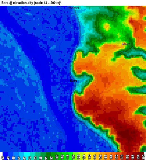
Below is the Elevation map of Baro, which displays elevation range with different colors. Scale of the first map is from 43 to 200 m (141 to 656 ft) with average elevation of 89.8 meters (=295 ft) [note 1]
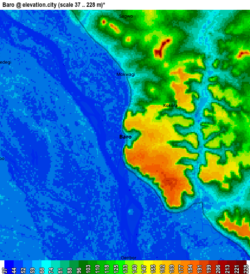
These maps also provides idea of topography and contour of this city, they are displayed at different zoom levels. More info about maps, scale and edge coordinates you can find below images.
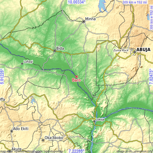
| \ | Map #1 | Map #2 | Topo.Map |
| Scale [m] | 43..200 m | 37..228 m | × |
| Scale [ft] | 141..656 ft | 121..748 ft | × |
| Average | 89.8 m = 295 ft | 78.6 m = 258 ft | × |
| Width | 9.66 km = 6 mi | 19.32 km = 12 mi | 309.2 km = 192.1 mi |
| Height | 9.66 km = 6 mi | 19.32 km = 12 mi | 309.2 km = 192.1 mi |
| ↑Max Latitude | 8.659097° | 8.702539° | 10.00334° |
| Latitude at center | 8.61565° | 8.61565° | 8.61565° |
| ↓Min Latitude | 8.572198° | 8.528741° | 7.22285° |
| ← Min Longitude | 6.374555° | 6.330609° | 5.01225° |
| Longitude center | 6.4185° | 6.4185° | 6.4185° |
| →Max Longitude | 6.462445° | 6.506391° | 7.82475° |
Nearby cities:
Cities around Baro sort by population:
• Bida elevation 118 m
68.5 km,  319°
319°
• Patigi 123 m
73.9 km,  279°
279°
• Lapai 169 m
50.5 km,  19°
19°
• Isanlu-Itedoijowa 323 m
74.5 km,  239°
239°
• Agaie 120 m
45 km,  345°
345°
• Koton-Karfe 51 m
71.7 km,  144°
144°
• Badeggi 82 m
57.6 km,  328°
328°
• Kwali 197 m
72.4 km,  65°
65°
• Toto 140 m
76.8 km,  109°
109°
• Isanlu 339 m
75.4 km, 241°
• Abaji 138 m
60 km, 105°
• Katcha 71 m
19.9 km, 324°
Multilingual:
 En español:
Baro elevación 94 m.
 En France:
Baro élévation 94 m.


Sources and notes:
- [note 1] Map square and city borders are not equal. Map elevation data is calculated only from area inside that square.
- [src 1] Elevation data from geonames database provided with same terms of usage.
- [src 2] The elevation map of Baro is generated using elevation data from NASA's 3 arcsec (90m) resolution SRTM data.
- [src 3] Base (background) map © OpenStreetMap contributors tiles are generated by Geofabrik and OpenTopoMap.
Copyright & License:
This Baro Elevation Map is licensed under CC BY-SA. You may reuse any part from this page, if you give a proper credit by linking to this URL:
 More info on terms of use page.