Nenehuaca elevation
Nenehuaca (Puebla, Chichiquila), Mexico elevation is 1841 meters and Nenehuaca elevation in feet is 6040 ft above sea level [src 1]. Nenehuaca is a populated place (feature code) with elevation that is 527 meters (1729 ft) bigger than average city elevation in Mexico.
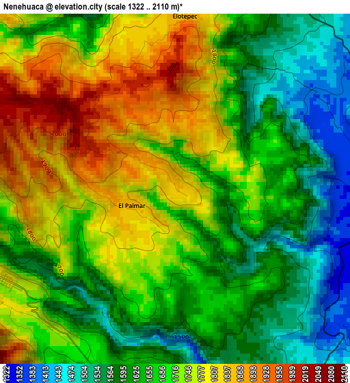
Below is the Elevation map of Nenehuaca, which displays elevation range with different colors. Scale of the first map is from 1322 to 2110 m (4337 to 6923 ft) with average elevation of 1690.3 meters (=5546 ft) [note 1]
These maps also provides idea of topography and contour of this city, they are displayed at different zoom levels. More info about maps, scale and edge coordinates you can find below images.
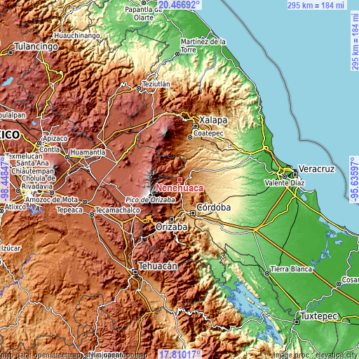
| \ | Map #1 | Topo.Map |
| Scale [m] | 1322..2110 m | × |
| Scale [ft] | 4337..6923 ft | × |
| Average | 1690.3 m = 5546 ft | × |
| Width | 9.23 km = 5.7 mi | 295.4 km = 183.6 mi |
| Height | 9.23 km = 5.7 mi | 295.4 km = 183.6 mi |
| ↑Max Latitude | 19.1854° | 20.46692° |
| Latitude at center | 19.14389° | 19.14389° |
| ↓Min Latitude | 19.10237° | 17.81017° |
| ← Min Longitude | -97.086165° | -98.44847° |
| Longitude center | -97.04222° | -97.04222° |
| →Max Longitude | -96.998275° | -95.63597° |
Nearby cities:
Cities around Nenehuaca sort by population:
• Huatusco elevation 1290 m
7.9 km,  86°
86°
• Coscomatepec de Bravo 1543 m
7.9 km,  183°
183°
• Chichiquila 1786 m
6.8 km,  337°
337°
• Elotepec 1849 m
4.9 km,  5°
5°
• El Palmar 1848 m
1.2 km,  247°
247°
• Ixpila 1133 m
8.4 km,  109°
109°
• Tozongo 1665 m
5.2 km,  202°
202°
• Xalatlaco 1526 m
10.5 km, 179°
• Alpatláhuac 1855 m
6 km,  243°
243°
• Calcahualco 1792 m
5.1 km, 242°
• Excola 2018 m
8.5 km,  266°
266°
• Cruz Verde 1943 m
7 km,  264°
264°
Multilingual:
 En español:
Nenehuaca elevación 1841 m.
 En France:
Nenehuaca élévation 1841 m.
 Auf Deutsch:
Nenehuaca höhe über dem Meeresspiegel ist 1841 m.

Sources and notes:
- [note 1] Map square and city borders are not equal. Map elevation data is calculated only from area inside that square.
- [src 1] Elevation data from geonames database provided with same terms of usage.
- [src 2] The elevation map of Nenehuaca is generated using elevation data from NASA's 3 arcsec (90m) resolution SRTM data.
- [src 3] Base (background) map © OpenStreetMap contributors tiles are generated by Geofabrik and OpenTopoMap.
Copyright & License:
This Nenehuaca Elevation Map is licensed under CC BY-SA. You may reuse any part from this page, if you give a proper credit by linking to this URL:
 More info on terms of use page.