Ixpila elevation
Ixpila (Veracruz, Huatusco), Mexico elevation is 1133 meters and Ixpila elevation in feet is 3717 ft above sea level [src 1]. Ixpila is a populated place (feature code) with elevation that is 181 meters (594 ft) smaller than average city elevation in Mexico.
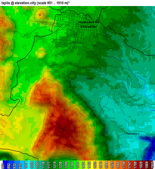
Below is the Elevation map of Ixpila, which displays elevation range with different colors. Scale of the first map is from 851 to 1910 m (2792 to 6266 ft) with average elevation of 1313.8 meters (=4310 ft) [note 1]
These maps also provides idea of topography and contour of this city, they are displayed at different zoom levels. More info about maps, scale and edge coordinates you can find below images.
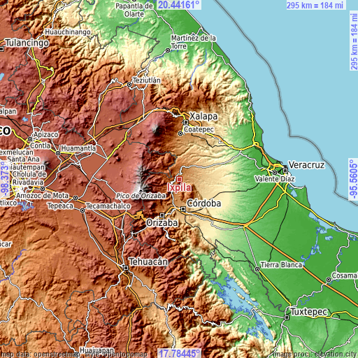
| \ | Map #1 | Topo.Map |
| Scale [m] | 851..1910 m | × |
| Scale [ft] | 2792..6266 ft | × |
| Average | 1313.8 m = 4310 ft | × |
| Width | 9.23 km = 5.7 mi | 295.4 km = 183.6 mi |
| Height | 9.23 km = 5.7 mi | 295.5 km = 183.6 mi |
| ↑Max Latitude | 19.159886° | 20.44161° |
| Latitude at center | 19.11837° | 19.11837° |
| ↓Min Latitude | 19.076843° | 17.78445° |
| ← Min Longitude | -97.010695° | -98.373° |
| Longitude center | -96.96675° | -96.96675° |
| →Max Longitude | -96.922805° | -95.5605° |
Nearby cities:
Cities around Ixpila sort by population:
• Huatusco elevation 1290 m
3.4 km,  358°
358°
• Coscomatepec de Bravo 1543 m
9.8 km,  238°
238°
• Ixhuatlán del Café 1355 m
7.7 km,  193°
193°
• Presidio 1330 m
5.5 km, 185°
• El Palmar 1848 m
9.4 km,  284°
284°
• Tlamatoca 1051 m
4.2 km,  131°
131°
• Comapa 1066 m
9.8 km,  58°
58°
• Tozongo 1665 m
10.1 km,  258°
258°
• Ixcatla 1067 m
6.9 km, 133°
• Sochiapa 1340 m
8.8 km,  18°
18°
• Nenehuaca 1841 m
8.4 km,  289°
289°
• Ixcapantla 1354 m
10.3 km,  182°
182°
Multilingual:
 En español:
Ixpila elevación 1133 m.
 En France:
Ixpila élévation 1133 m.


Sources and notes:
- [note 1] Map square and city borders are not equal. Map elevation data is calculated only from area inside that square.
- [src 1] Elevation data from geonames database provided with same terms of usage.
- [src 2] The elevation map of Ixpila is generated using elevation data from NASA's 3 arcsec (90m) resolution SRTM data.
- [src 3] Base (background) map © OpenStreetMap contributors tiles are generated by Geofabrik and OpenTopoMap.
Copyright & License:
This Ixpila Elevation Map is licensed under CC BY-SA. You may reuse any part from this page, if you give a proper credit by linking to this URL:
 More info on terms of use page.