Tozongo elevation
Tozongo (Veracruz, Coscomatepec), Mexico elevation is 1665 meters and Tozongo elevation in feet is 5463 ft above sea level [src 1]. Tozongo is a populated place (feature code) with elevation that is 351 meters (1152 ft) bigger than average city elevation in Mexico.
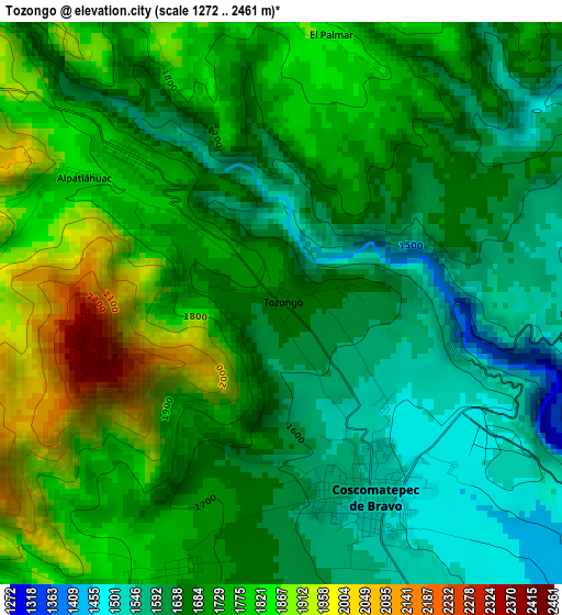
Below is the Elevation map of Tozongo, which displays elevation range with different colors. Scale of the first map is from 1272 to 2461 m (4173 to 8074 ft) with average elevation of 1709.3 meters (=5608 ft) [note 1]
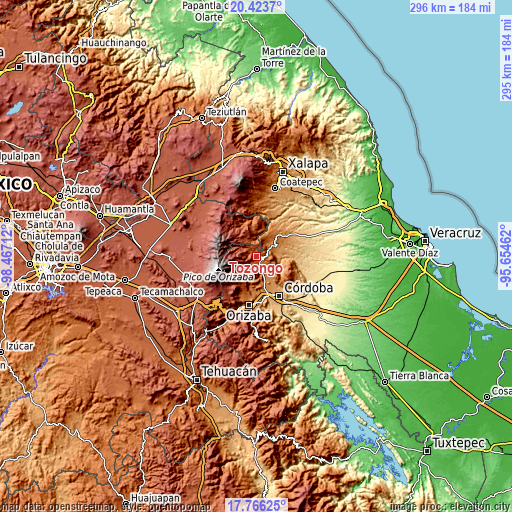
These maps also provides idea of topography and contour of this city, they are displayed at different zoom levels. More info about maps, scale and edge coordinates you can find below images.
| \ | Map #1 | Topo.Map |
| Scale [m] | 1272..2461 m | × |
| Scale [ft] | 4173..8074 ft | × |
| Average | 1709.3 m = 5608 ft | × |
| Width | 9.23 km = 5.7 mi | 295.5 km = 183.6 mi |
| Height | 9.23 km = 5.7 mi | 295.5 km = 183.6 mi |
| ↑Max Latitude | 19.141831° | 20.4237° |
| Latitude at center | 19.10031° | 19.10031° |
| ↓Min Latitude | 19.058779° | 17.76625° |
| ← Min Longitude | -97.104815° | -98.46712° |
| Longitude center | -97.06087° | -97.06087° |
| →Max Longitude | -97.016925° | -95.65462° |
Nearby cities:
Cities around Tozongo sort by population:
• Coscomatepec de Bravo elevation 1543 m
3.4 km,  154°
154°
• Ixhuatlán del Café 1355 m
9.8 km,  124°
124°
• Tomatlán 1364 m
9.4 km, 145°
• El Palmar 1848 m
4.5 km,  10°
10°
• Tetlaxco 1656 m
6.7 km,  182°
182°
• Xalatlaco 1526 m
6 km,  159°
159°
• Alpatláhuac 1855 m
4.1 km,  302°
302°
• Ayahualulco 2330 m
7.9 km,  273°
273°
• Calcahualco 1792 m
3.6 km,  313°
313°
• Excola 2018 m
7.8 km, 303°
• Nenehuaca 1841 m
5.2 km,  22°
22°
• Cruz Verde 1943 m
6.5 km, 309°
Multilingual:
 En español:
Tozongo elevación 1665 m.
 En France:
Tozongo élévation 1665 m.
 Auf Deutsch:
Tozongo höhe über dem Meeresspiegel ist 1665 m.

Sources and notes:
- [note 1] Map square and city borders are not equal. Map elevation data is calculated only from area inside that square.
- [src 1] Elevation data from geonames database provided with same terms of usage.
- [src 2] The elevation map of Tozongo is generated using elevation data from NASA's 3 arcsec (90m) resolution SRTM data.
- [src 3] Base (background) map © OpenStreetMap contributors tiles are generated by Geofabrik and OpenTopoMap.
Copyright & License:
This Tozongo Elevation Map is licensed under CC BY-SA. You may reuse any part from this page, if you give a proper credit by linking to this URL:
 More info on terms of use page.