Xalatlaco elevation
Xalatlaco (Veracruz, Coscomatepec), Mexico elevation is 1526 meters and Xalatlaco elevation in feet is 5007 ft above sea level [src 1]. Xalatlaco is a populated place (feature code) with elevation that is 212 meters (696 ft) bigger than average city elevation in Mexico.
Below is the Elevation map of Xalatlaco, which displays elevation range with different colors. Scale of the first map is from 1169 to 2354 m (3835 to 7723 ft) with average elevation of 1578.6 meters (=5179 ft) [note 1]
These maps also provides idea of topography and contour of this city, they are displayed at different zoom levels. More info about maps, scale and edge coordinates you can find below images.
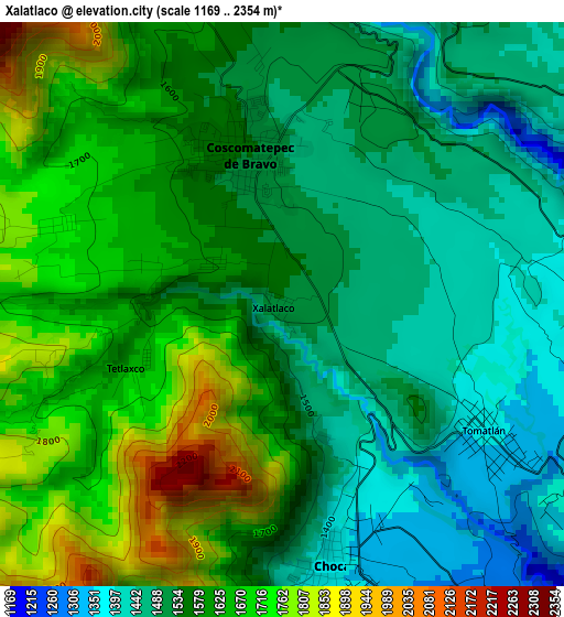
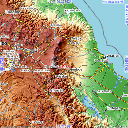
| \ | Map #1 | Topo.Map |
| Scale [m] | 1169..2354 m | × |
| Scale [ft] | 3835..7723 ft | × |
| Average | 1578.6 m = 5179 ft | × |
| Width | 9.24 km = 5.7 mi | 295.6 km = 183.7 mi |
| Height | 9.24 km = 5.7 mi | 295.6 km = 183.7 mi |
| ↑Max Latitude | 19.091253° | 20.37353° |
| Latitude at center | 19.04972° | 19.04972° |
| ↓Min Latitude | 19.008176° | 17.71526° |
| ← Min Longitude | -97.085055° | -98.44736° |
| Longitude center | -97.04111° | -97.04111° |
| →Max Longitude | -96.997165° | -95.63486° |
Nearby cities:
Cities around Xalatlaco sort by population:
• Coscomatepec de Bravo elevation 1543 m
2.6 km,  346°
346°
• Chocamán 1358 m
4.3 km,  168°
168°
• Xocotla 2013 m
7.4 km,  238°
238°
• Ixhuatlán del Café 1355 m
6 km,  88°
88°
• Tomatlán 1364 m
3.9 km,  122°
122°
• Tetla 1513 m
7.3 km,  196°
196°
• Presidio 1330 m
7.6 km,  73°
73°
• San José Neria 1210 m
7.7 km,  144°
144°
• Tetlaxco 1656 m
2.6 km,  246°
246°
• Tozongo 1665 m
6 km,  339°
339°
• Tecama 1192 m
7.8 km,  131°
131°
• Ixcapantla 1354 m
7.9 km,  109°
109°
Multilingual:
 En español:
Xalatlaco elevación 1526 m.
 En France:
Xalatlaco élévation 1526 m.
 Auf Deutsch:
Xalatlaco höhe über dem Meeresspiegel ist 1526 m.

Sources and notes:
- [note 1] Map square and city borders are not equal. Map elevation data is calculated only from area inside that square.
- [src 1] Elevation data from geonames database provided with same terms of usage.
- [src 2] The elevation map of Xalatlaco is generated using elevation data from NASA's 3 arcsec (90m) resolution SRTM data.
- [src 3] Base (background) map © OpenStreetMap contributors tiles are generated by Geofabrik and OpenTopoMap.
Copyright & License:
This Xalatlaco Elevation Map is licensed under CC BY-SA. You may reuse any part from this page, if you give a proper credit by linking to this URL:
 More info on terms of use page.