Chocamán elevation
Chocamán (Veracruz), Mexico elevation is 1358 meters and Chocamán elevation in feet is 4455 ft above sea level [src 1]. Chocamán is a seat of a second-order administrative division (feature code) with elevation that is 44 meters (144 ft) bigger than average city elevation in Mexico.
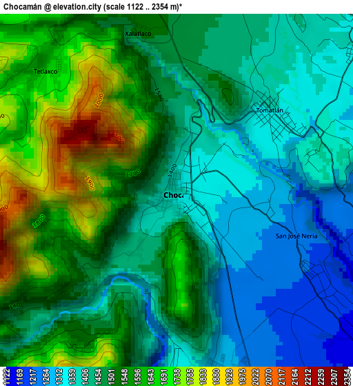
Below is the Elevation map of Chocamán, which displays elevation range with different colors. Scale of the first map is from 1122 to 2354 m (3681 to 7723 ft) with average elevation of 1492.7 meters (=4897 ft) [note 1]
These maps also provides idea of topography and contour of this city, they are displayed at different zoom levels. More info about maps, scale and edge coordinates you can find below images.
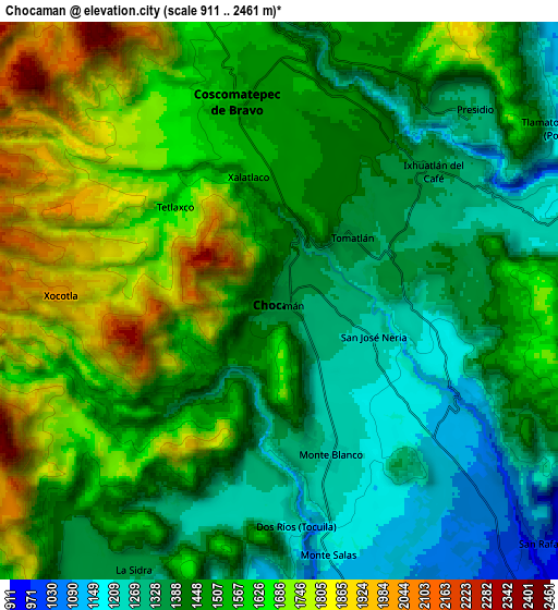
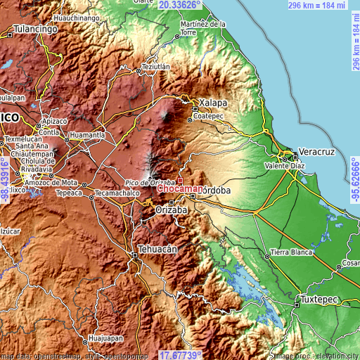
| \ | Map #1 | Map #2 | Topo.Map |
| Scale [m] | 1122..2354 m | 911..2461 m | × |
| Scale [ft] | 3681..7723 ft | 2989..8074 ft | × |
| Average | 1492.7 m = 4897 ft | 1506.5 m = 4943 ft | × |
| Width | 9.24 km = 5.7 mi | 18.48 km = 11.5 mi | 295.6 km = 183.7 mi |
| Height | 9.24 km = 5.7 mi | 18.48 km = 11.5 mi | 295.7 km = 183.7 mi |
| ↑Max Latitude | 19.053683° | 19.095215° | 20.33626° |
| Latitude at center | 19.01214° | 19.01214° | 19.01214° |
| ↓Min Latitude | 18.970587° | 18.929023° | 17.67739° |
| ← Min Longitude | -97.076855° | -97.120801° | -98.43916° |
| Longitude center | -97.03291° | -97.03291° | -97.03291° |
| →Max Longitude | -96.988965° | -96.945019° | -95.62666° |
Nearby cities:
Cities around Chocamán sort by population:
• Coscomatepec de Bravo elevation 1543 m
6.9 km,  347°
347°
• Monte Blanco 1254 m
5.4 km,  161°
161°
• Ixhuatlán del Café 1355 m
6.7 km,  49°
49°
• Tomatlán 1364 m
3.2 km, 49°
• Tocuila 1221 m
7.1 km,  166°
166°
• Tetla 1513 m
4 km,  226°
226°
• San José Neria 1210 m
4.1 km,  120°
120°
• Santa Lucía Potrerillo 1292 m
4.9 km, 169°
• Tetlaxco 1656 m
4.5 km,  313°
313°
• Xalatlaco 1526 m
4.3 km, 348°
• Tecama 1192 m
5.1 km,  100°
100°
• Ixcapantla 1354 m
6.7 km,  77°
77°
Multilingual:
 En español:
Chocaman elevación 1358 m.
 En France:
Chocamán élévation 1358 m.
 Auf Deutsch:
Chocamán höhe über dem Meeresspiegel ist 1358 m.

Sources and notes:
- [note 1] Map square and city borders are not equal. Map elevation data is calculated only from area inside that square.
- [src 1] Elevation data from geonames database provided with same terms of usage.
- [src 2] The elevation map of Chocamán is generated using elevation data from NASA's 3 arcsec (90m) resolution SRTM data.
- [src 3] Base (background) map © OpenStreetMap contributors tiles are generated by Geofabrik and OpenTopoMap.
Copyright & License:
This Chocamán Elevation Map is licensed under CC BY-SA. You may reuse any part from this page, if you give a proper credit by linking to this URL:
 More info on terms of use page.